
Bestand:1825 Prairie du Chien Line.jpg

Grootte van deze voorvertoning: 463 × 599 pixels. Andere resoluties: 185 × 240 pixels | 371 × 480 pixels | 593 × 768 pixels | 1.275 × 1.650 pixels.
Oorspronkelijk bestand (1.275 × 1.650 pixels, bestandsgrootte: 495 kB, MIME-type: image/jpeg)
| Dit is een bestand van Wikimedia Commons. Onderstaande beschrijving komt van de beschrijving van het bestand daar. |
Beschrijving
| Beschrijving |
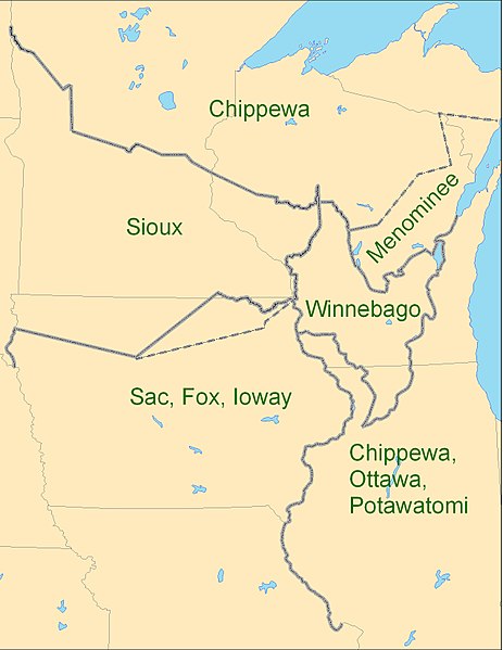
English: Map showing the boundaries between the Sioux (Dakota), Chippewa (Ojibwe), Winnebago (Ho-chunk), Menominee (Menomini), Sauk and Fox (Sac and Fox Nation), Ioway, and the Chippewa-Ottawa-Potawatomi (Council of Three Fires) as per 1825 Treaty of Prairie du Chien |
| Datum | |
| Bron | Eigen werk |
| Auteur | CJLippert |
Due to uncertainty of Menominee and Ioway boundaries, the parties agreed to adjustments to the 1825-established Prairie du Chien Line once the Menominee and Ioway have determined their boundaries. The adjustment lines shown as dashed boundaries.
Licentie
Ik, de auteursrechthebbende van dit werk, maak het hierbij onder de volgende licentie beschikbaar:
Dit bestand is gelicenseerd onder de Creative Commons-licentie Naamsvermelding 3.0 Unported
- De gebruiker mag:
- Delen – het werk kopiëren, verspreiden en doorgeven
- Remixen – afgeleide werken maken
- Onder de volgende voorwaarden:
- naamsvermelding – U moet op een gepaste manier aan naamsvermelding doen, een link naar de licentie geven, en aangeven of er wijzigingen in het werk zijn aangebracht. U mag dit op elke redelijke manier doen, maar niet zodanig dat de indruk wordt gewekt dat de licentiegever instemt met uw werk of uw gebruik van zijn werk.
Bestandsgeschiedenis
Klik op een datum/tijd om het bestand te zien zoals het destijds was.
| Datum/tijd | Miniatuur | Afmetingen | Gebruiker | Opmerking | |
|---|---|---|---|---|---|
| huidige versie | 3 sep 2009 21:26 | | 1.275 × 1.650 (495 kB) | CJLippert | {{Information |Description={{en|1=Map showing the boundaries between the Sioux (w:Dakota), Chippewa (w:Ojibwe), Winnebago (w:Ho-chunk), Menominee (w:Menomini), Sauk and Fox (w:Sac and Fox Nation), w:Ioway, and the Chippewa-Ottawa-P |
Bestandsgebruik
Dit bestand wordt op de volgende pagina gebruikt:
Globaal bestandsgebruik
De volgende andere wiki's gebruiken dit bestand:
- Gebruikt op ca.wikipedia.org
- Gebruikt op en.wikipedia.org
- Gebruikt op en.wikiversity.org
- Gebruikt op es.wikipedia.org
- Gebruikt op fr.wikipedia.org
- Gebruikt op hr.wikipedia.org
- Gebruikt op oc.wikipedia.org
- Gebruikt op sv.wikipedia.org
- Gebruikt op uk.wikipedia.org