
Bestand:2009-09-29 Samoa Island Region earthquake location.jpg
Geen hogere resolutie beschikbaar.
2009-09-29_Samoa_Island_Region_earthquake_location.jpg (420 × 468 pixels, bestandsgrootte: 57 kB, MIME-type: image/jpeg)
| Dit is een bestand van Wikimedia Commons. Onderstaande beschrijving komt van de beschrijving van het bestand daar. |


Beschrijving
| Beschrijving |
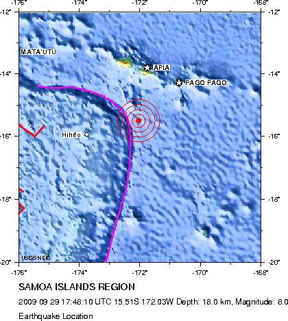
English: Earthquake location map. Major Tectonic Boundaries: Subduction Zones -purple, Ridges -red and Transform Faults -green
Deutsch: Erdbebenlagekarte. |
| Datum | |
| Bron | http://neic.usgs.gov/neis/eq_depot/2009/eq_090929_mdbi/neic_mdbi_l.html |
| Auteur | United States Geological Survey |
Licentie
Deze afbeelding bevindt zich in het publiek domein omdat het materiaal bevat dat oorspronkelijk afkomstig is van de United States Geological Survey, een agentschap van de United States Department of the Interior. Voor meer informatie, zie het officiële USGS-auteursrechtenbeleid
|
Bestandsgeschiedenis
Klik op een datum/tijd om het bestand te zien zoals het destijds was.
| Datum/tijd | Miniatuur | Afmetingen | Gebruiker | Opmerking | |
|---|---|---|---|---|---|
| huidige versie | 1 okt 2009 17:05 | | 420 × 468 (57 kB) | Avenue | Updated version from USGS website: http://neic.usgs.gov/neis/eq_depot/2009/eq_090929_mdbi/neic_mdbi.jpg Created by USGS, so public domain. |
| 29 sep 2009 22:52 |  | 420 × 468 (57 kB) | Matthiasb | {{Information |Description={{en|1=Earthquake location map. Major Tectonic Boundaries: Subduction Zones -purple, Ridges -red and Transform Faults -green}} {{de|1=Erdbebenlagekarte. }} |Source=http://neic.usgs.gov/neis/eq_depot/2009/eq_090929_mdbi/neic_mdbi |
Bestandsgebruik
Dit bestand wordt op de volgende pagina gebruikt:
Globaal bestandsgebruik
De volgende andere wiki's gebruiken dit bestand:
- Gebruikt op de.wikipedia.org
- Gebruikt op de.wikinews.org
- Gebruikt op en.wikinews.org
- Gebruikt op es.wikipedia.org
- Gebruikt op es.wikinews.org
- Gebruikt op eu.wikipedia.org
- Gebruikt op fi.wikipedia.org
- Gebruikt op fr.wikipedia.org
- Gebruikt op he.wikipedia.org
- Gebruikt op hif.wikipedia.org
- Gebruikt op it.wikipedia.org
- Gebruikt op ja.wikipedia.org
- Gebruikt op ms.wikipedia.org
- Gebruikt op no.wikipedia.org
- Gebruikt op pl.wikipedia.org
- Gebruikt op pl.wikinews.org
- Gebruikt op pt.wikipedia.org
- Gebruikt op pt.wikinews.org
- Gebruikt op ro.wikipedia.org
- Gebruikt op th.wikipedia.org
- Gebruikt op www.wikidata.org
- Gebruikt op zh.wikipedia.org