
Bestand:Bush Barrow - geograph.org.uk - 1622275.jpg
Bush_Barrow_-_geograph.org.uk_-_1622275.jpg (640 × 480 pixels, bestandsgrootte: 76 kB, MIME-type: image/jpeg)
| Dit is een bestand van Wikimedia Commons. Onderstaande beschrijving komt van de beschrijving van het bestand daar. |
Beschrijving
| Beschrijving |
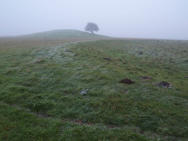
English: Bush Barrow "In the 1720s William Stukeley had called it the bush barrow after trees planted on the top (though the county people knew it as the green barrow)" http://www.britarch.ac.uk/ba/ba104/feat1.shtml .
"This very large bowl barrow in the Normanton Down barrow group, just south of Stonehenge, measures over 40m in diameter and stands today 3m high. It was excavated in 1808 by William Cunnington and Sir Richard Colt Hoare. The primary burial was of a tall, stout, adult man, buried lying on his back. The grave goods placed with him show that this was a princely burial from about 1900 -1700 B.C. It is Britain's richest and most important Bronze Age burial" http://www.wiltshireheritage.org.uk/galleries/index.php?Action=3&obID=89&prevID=9 . In the foreground is a round barrow. Together they form part of the Normanton Down Barrows. The first link gives much detail about the excavation of Bush Barrow and the site as a whole. |
| Datum | |
| Bron | From geograph.org.uk |
| Auteur | Derek Harper |
| Naamsvermelding (required by the license) | Derek Harper / Bush Barrow / |
| Cameralocatie | | Deze en andere afbeeldingen in: OpenStreetMap |
|---|
_heading:112.00&language=nl)
| Objectlocatie | | Deze en andere afbeeldingen in: OpenStreetMap |
|---|
_heading:112.00&language=nl)
Licentie

|
Deze afbeelding komt uit de Geograph British Isles-collectie. Zie de pagina van deze foto op de website van Geograph voor contactinformatie van de fotograaf. Het auteursrecht van deze foto is in handen van Derek Harper en de foto is gelicenceerd voor hergebruik onder de Creative Commons Naamsvermelding-Gelijk delen 2.0 licentie.
|
- De gebruiker mag:
- Delen – het werk kopiëren, verspreiden en doorgeven
- Remixen – afgeleide werken maken
- Onder de volgende voorwaarden:
- naamsvermelding – U moet op een gepaste manier aan naamsvermelding doen, een link naar de licentie geven, en aangeven of er wijzigingen in het werk zijn aangebracht. U mag dit op elke redelijke manier doen, maar niet zodanig dat de indruk wordt gewekt dat de licentiegever instemt met uw werk of uw gebruik van zijn werk.
- Gelijk delen – Als u het werk heeft geremixt, veranderd, of erop heeft voortgebouwd, moet u het gewijzigde materiaal verspreiden onder dezelfde licentie als het oorspronkelijke werk, of een daarmee compatibele licentie.
Bestandsgeschiedenis
Klik op een datum/tijd om het bestand te zien zoals het destijds was.
| Datum/tijd | Miniatuur | Afmetingen | Gebruiker | Opmerking | |
|---|---|---|---|---|---|
| huidige versie | 4 mrt 2011 14:33 | | 640 × 480 (76 kB) | GeographBot | == {{int:filedesc}} == {{Information |description={{en|1=Bush Barrow "In the 1720s William Stukeley had called it the bush barrow after trees planted on the top (though the county people knew it as the green barrow)" http://www.britarch.ac.uk/ |
Bestandsgebruik
Dit bestand wordt op de volgende pagina gebruikt:
Globaal bestandsgebruik
De volgende andere wiki's gebruiken dit bestand:
- Gebruikt op de.wikipedia.org
- Gebruikt op en.wikipedia.org
- Gebruikt op hy.wikipedia.org
- Gebruikt op it.wikipedia.org
- Gebruikt op www.wikidata.org