
Bestand:Japanese Occupation - Map.jpg
Oorspronkelijk bestand (1.119 × 857 pixels, bestandsgrootte: 482 kB, MIME-type: image/jpeg)
| Dit is een bestand van Wikimedia Commons. Onderstaande beschrijving komt van de beschrijving van het bestand daar. |

|
Bestand:Japanese Occupation of China 1940.svg is een vectorversie van dit bestand. Indien niet van slechtere kwaliteit dient deze gebruikt te worden in plaats van deze rasterafbeelding.
File:Japanese Occupation - Map.jpg → File:Japanese Occupation of China 1940.svg
Zie Help:SVG voor meer informatie. |
 |
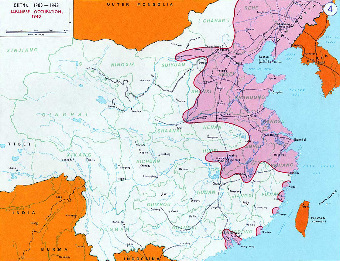
- Description: English: Japanese Occupation - 1940閩南語 / Bân-lâm-gú:Ji̍t-pún 1940-nî tī Tiong-kok tsiàm ê sóo-tsāi(hún-âng-sik).中文:中国抗日战争中,1940年日军占领区(粉紅色)。
- Source: www.dean.usma.edu - The photo source linked here only has the photo in this low-resolution JPG format.
- Other versions: File:Second Sino-Japanese War WW2.png
- Background information:
In 1938 the predecessors of what is today The Department of History at the United States Military Academy began developing a series of campaign atlases to aid in teaching cadets a course entitled, "History of the Military Art." Since then, the Department has produced over six atlases and more than one thousand maps, encompassing not only America’s wars but global conflicts as well.
In keeping abreast with today's technology, the Department of History is providing these maps on the internet as part of the department's outreach program. The maps were created by the United States Military Academy’s Department of History and are the digital versions from the atlases printed by the United States Defense Printing Agency. We gratefully acknowledge the accomplishments of the department's former cartographer, Mr. Edward J. Krasnoborski, along with the works of our present cartographer, Mr. Frank Martini.
Please be aware that these maps are large in file size and may require substantial download times.
Deze afbeelding is een werk van een soldaat of werknemer van de U.S. Army, genomen of gemaakt tijdens de uitvoering van diens officiële taken. Als werk van de federale overheid van de Verenigde Staten bevindt deze afbeelding zich in het publiek domein.
|
 |
derivative works
Afgeleide werken van dit bestand: OcupaciónJaponesaDeChina1940.svg
Bestandsgeschiedenis
Klik op een datum/tijd om het bestand te zien zoals het destijds was.
| Datum/tijd | Miniatuur | Afmetingen | Gebruiker | Opmerking | |
|---|---|---|---|---|---|
| huidige versie | 14 nov 2012 21:17 | | 1.119 × 857 (482 kB) | Mys 721tx | Reverted to version as of 22:05, 9 March 2010 Revert to larger picture. |
| 14 nov 2012 05:58 |  | 699 × 600 (111 kB) | Amysze123 | ||
| 10 mrt 2010 00:05 |  | 1.119 × 857 (482 kB) | Ras67 | rotated and cropped | |
| 17 jun 2005 10:32 |  | 1.141 × 870 (172 kB) | W.wolny |
Bestandsgebruik
Dit bestand wordt op de volgende 3 pagina's gebruikt:
Globaal bestandsgebruik
De volgende andere wiki's gebruiken dit bestand:
- Gebruikt op ar.wikipedia.org
- Gebruikt op be.wikipedia.org
- Gebruikt op bs.wikipedia.org
- Gebruikt op ca.wikipedia.org
- Gebruikt op cs.wikipedia.org
- Gebruikt op da.wikipedia.org
- Gebruikt op el.wikipedia.org
- Gebruikt op en.wikipedia.org
- Gebruikt op en.wikibooks.org
- Gebruikt op es.wikipedia.org
- Gebruikt op et.wikipedia.org
- Gebruikt op fi.wikipedia.org
- Gebruikt op fr.wikipedia.org
- Gebruikt op he.wikipedia.org
- Gebruikt op hr.wikipedia.org
- Gebruikt op hu.wikipedia.org
- Gebruikt op hy.wikipedia.org
- Gebruikt op id.wikipedia.org
- Gebruikt op ja.wikipedia.org
- Gebruikt op jv.wikipedia.org
- Gebruikt op kk.wikipedia.org
- Gebruikt op ko.wikipedia.org
- Gebruikt op la.wikipedia.org
- Gebruikt op lv.wikipedia.org
- Gebruikt op ms.wikipedia.org
- Gebruikt op my.wikipedia.org
- Gebruikt op no.wikipedia.org
- Gebruikt op pt.wikipedia.org
Globaal gebruik van dit bestand bekijken.