
Bestand:Kaart van Maastricht door Larcher d'Aubencourt, 1748, detail omgeving Duitse Poort, Wyck.jpg

Grootte van deze voorvertoning: 800 × 582 pixels. Andere resoluties: 320 × 233 pixels | 640 × 466 pixels | 904 × 658 pixels.
Oorspronkelijk bestand (904 × 658 pixels, bestandsgrootte: 263 kB, MIME-type: image/jpeg)
| Dit is een bestand van Wikimedia Commons. Onderstaande beschrijving komt van de beschrijving van het bestand daar. |
Beschrijving
| Beschrijving |
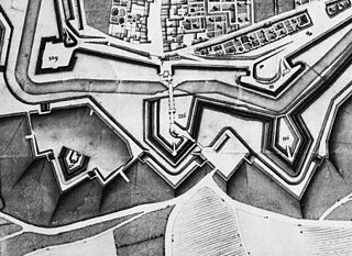
English: Maastricht, the Netherlands. Detail of a map showing a part of the city in 1749. The map by French military engineer Jean-Baptiste Larcher d'Aubencourt was used to built the Maquette of Maastricht (1752), now in the Musée de Beaux Arts in Lille, France. Here the area around Duitse Poort (German or Aachen Gate, r) in Wyck with ravelin De Raaf (116), bastions Parma (109) and Galgen (Gallows, 111) and lunettes Valkenburg (117) and Eghien (116). |
| Datum | |
| Bron | http://beeldbank.cultureelerfgoed.nl/alle-afbeeldingen/weergave/search/layout/result/indeling/detail/start/2?searchfield=Larcher+d%5C%5C%5C%27Aubancourt |
| Auteur | Jean-Baptiste Larcher d'Aubencourt, 1749 |
Licentie
|
Dit werk bevindt zich in het publiek domein in landen en gebieden waar de auteursrechttermijn het leven van de auteur plus 100 jaar of minder is. | |
| Van dit bestand is vastgesteld dat er geen bekende auteursrechtaanspraken op rusten, alle aanverwante en naburige rechten daarbij inbegrepen. | |
Bestandsgeschiedenis
Klik op een datum/tijd om het bestand te zien zoals het destijds was.
| Datum/tijd | Miniatuur | Afmetingen | Gebruiker | Opmerking | |
|---|---|---|---|---|---|
| huidige versie | 11 jan 2015 01:56 | | 904 × 658 (263 kB) | Kleon3 | User created page with UploadWizard |
Bestandsgebruik
Dit bestand wordt op de volgende pagina gebruikt: