
Bestand:Magnolia virginiana range map 3.png
Grootte van deze voorvertoning: 600 × 600 pixels. Andere resoluties: 240 × 240 pixels | 480 × 480 pixels | 768 × 768 pixels | 1.024 × 1.024 pixels | 2.048 × 2.048 pixels | 2.977 × 2.977 pixels.
Oorspronkelijk bestand (2.977 × 2.977 pixels, bestandsgrootte: 164 kB, MIME-type: image/png)
| Dit is een bestand van Wikimedia Commons. Onderstaande beschrijving komt van de beschrijving van het bestand daar. |
Beschrijving
| Beschrijving |
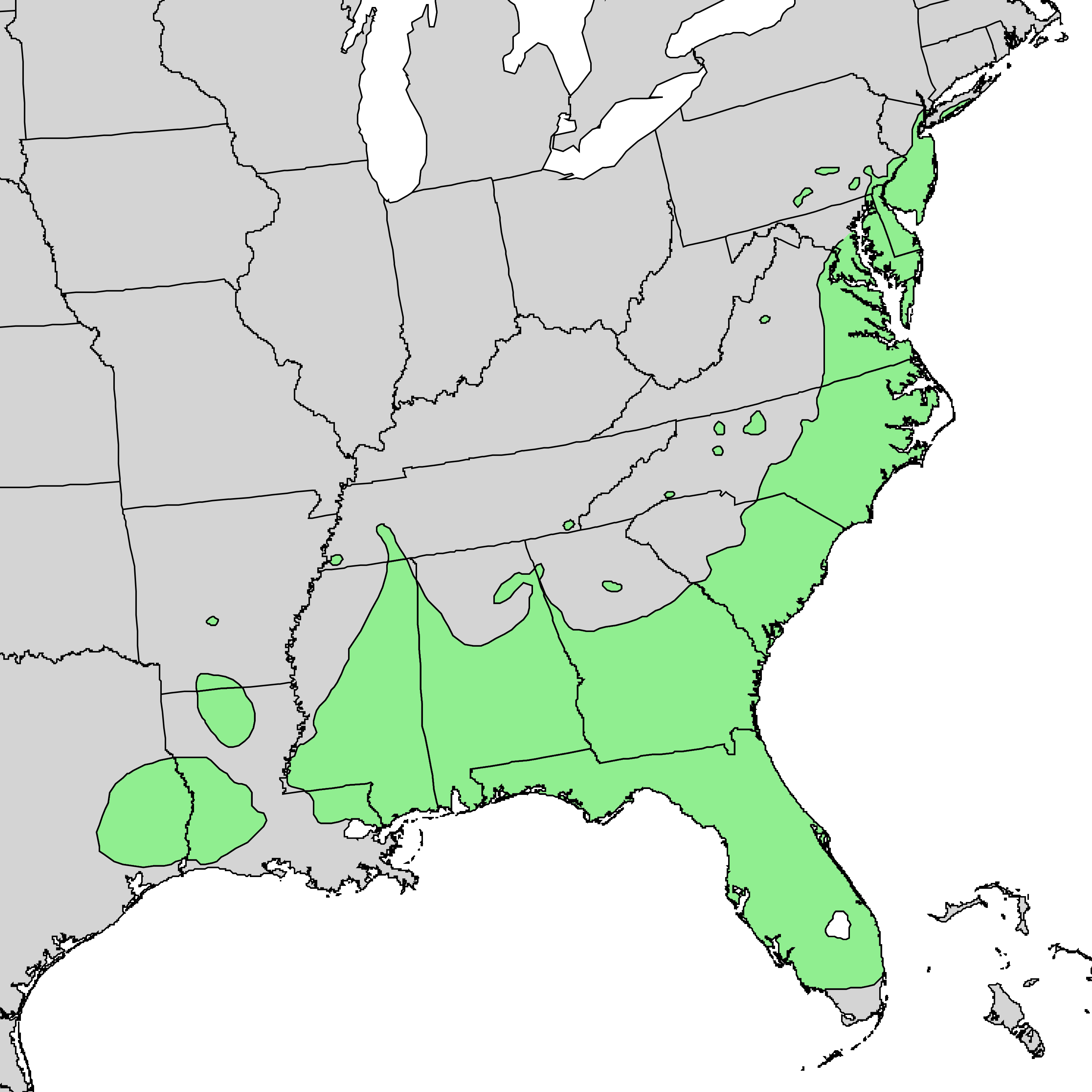
English: Range map of Magnolia virginica |
| Datum | |
| Bron | Digital representation of "Atlas of United States Trees" by Elbert L. Little, Jr. [1] |
| Auteur | U.S. Geological Survey |
Licentie
Deze afbeelding bevindt zich in het publiek domein omdat het materiaal bevat dat oorspronkelijk afkomstig is van de United States Geological Survey, een agentschap van de United States Department of the Interior. Voor meer informatie, zie het officiële USGS-auteursrechtenbeleid
|
Oorspronkelijk uploadlogboek
De oorspronkelijke beschrijving van deze afbeelding stond hier. Alle volgende gebruikersnamen verwijzen naar en.wikipedia.
- 2010-05-02 22:51 Masebrock 733×671× (124799 bytes) {{Information |Description=Range map of Magnolia virginica |Source=Digital representation of "Atlas of United States Trees" by Elbert L. Little, Jr. [http://esp.cr.usgs.gov/data/atlas/little/] |Date=1999 |Author=U.S. Geological Survey |Permission={{PD-USG
Bestandsgeschiedenis
Klik op een datum/tijd om het bestand te zien zoals het destijds was.
| Datum/tijd | Miniatuur | Afmetingen | Gebruiker | Opmerking | |
|---|---|---|---|---|---|
| huidige versie | 3 jan 2014 17:54 | | 2.977 × 2.977 (164 kB) | Nonenmac | higher resolution |
| 10 sep 2011 05:16 |  | 1.200 × 1.200 (64 kB) | Nonenmac | Removed striping and changed to indexed color mode. | |
| 7 aug 2010 22:10 |  | 733 × 671 (122 kB) | GreenZmiy | {{Information |Description={{en|Range map of Magnolia virginica}} |Source=Transferred from [http://en.wikipedia.org en.wikipedia]<br/> (Original text : ''Digital representation of "Atlas of United States Trees" by Elbert L. Little, Jr. [http://esp.cr.usgs |
Bestandsgebruik
Dit bestand wordt op de volgende pagina gebruikt:
Globaal bestandsgebruik
De volgende andere wiki's gebruiken dit bestand:
- Gebruikt op ab.wikipedia.org
- Gebruikt op ar.wikipedia.org
- Gebruikt op arz.wikipedia.org
- Gebruikt op azb.wikipedia.org
- Gebruikt op ca.wikipedia.org
- Gebruikt op ceb.wikipedia.org
- Gebruikt op cs.wikipedia.org
- Gebruikt op en.wikipedia.org
- Gebruikt op es.wikipedia.org
- Gebruikt op fa.wikipedia.org
- Gebruikt op koi.wikipedia.org
- Gebruikt op la.wikipedia.org
- Gebruikt op no.wikipedia.org
- Gebruikt op pl.wikipedia.org
- Gebruikt op pt.wikipedia.org
- Gebruikt op ru.wikipedia.org
- Gebruikt op sv.wikipedia.org
- Gebruikt op th.wikipedia.org
- Gebruikt op udm.wikipedia.org
- Gebruikt op uk.wikipedia.org
- Gebruikt op uz.wikipedia.org
- Gebruikt op www.wikidata.org