
Bestand:Map Gaul divisions 481-de.svg

Oorspronkelijk bestand (SVG-bestand, nominaal 755 × 784 pixels, bestandsgrootte: 103 kB)
| Dit is een bestand van Wikimedia Commons. Onderstaande beschrijving komt van de beschrijving van het bestand daar. |
Beschrijving
| Beschrijving |
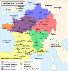
Deutsch: Territoriale Aufteilung Galliens in Jahr 481 n. Chr.
Reich der Alemannen
Reich der Burgunder
Reich der Franken
Westgotenreich
Reich des Syagrius
Aremorica Français : La division de la Gaule en 481. |
| Datum | (UTC) |
| Bron | |
| Auteur |
|
| Andere versies |
[]
See also |


| Dit is een geretoucheerde foto, wat betekent dat de originele versie digitaal aangepast is. Aanpassingen: Deutsche Übersetzung / traduction allemand. Het origineel kan hier bekeken worden: Map Gaul divisions 481-fr.svg. Aanpassingen gedaan door Furfur.
|
|
Dit werk bevindt zich in het publiek domein in landen en gebieden waar de auteursrechttermijn het leven van de auteur plus 70 jaar of minder is.
| |
| Van dit bestand is vastgesteld dat er geen bekende auteursrechtaanspraken op rusten, alle aanverwante en naburige rechten daarbij inbegrepen. | |
Oorspronkelijk uploadlogboek
This image is a derivative work of the following images:
- File:La_division_de_la_Gaule_en_481.svg licensed with PD-old
- 2010-04-27T20:48:50Z Romain0 755x784 (289302 Bytes) Courts d'eau + légendes.
- 2010-04-06T21:28:15Z Romain0 755x784 (281141 Bytes) Légende.
- 2010-03-27T09:29:13Z Romain0 755x784 (186086 Bytes) Légende.
- 2010-02-24T22:16:00Z Romain0 755x784 (177843 Bytes) Idem.
- 2010-02-24T22:09:36Z Romain0 755x784 (185174 Bytes) Correction légende.
- 2010-02-16T18:17:32Z Romain0 755x784 (185219 Bytes) Caractères.
- 2010-02-16T18:15:37Z Romain0 755x784 (179375 Bytes) Caractères.
- 2010-02-15T21:11:27Z Romain0 755x784 (177265 Bytes) Légende.
- 2010-02-15T21:04:11Z Romain0 755x784 (182690 Bytes) Fleuve.
- 2010-02-15T21:02:50Z Romain0 755x784 (187558 Bytes) allégement.
- 2010-02-15T20:57:18Z Romain0 755x784 (181735 Bytes) {{Information |Description={{fr|1=La division de la Gaule en 481.}} |Source=Travail personnel sur un fond de carte de [[User:Historicair|historicair]] : [[:Image:Blank map of Gaul 1st century BC.svg]]. D'après [[Paul Vidal d
Uploaded with derivativeFX
Bestandsgeschiedenis
Klik op een datum/tijd om het bestand te zien zoals het destijds was.
| Datum/tijd | Miniatuur | Afmetingen | Gebruiker | Opmerking | |
|---|---|---|---|---|---|
| huidige versie | 4 sep 2018 10:51 | | 755 × 784 (103 kB) | Furfur | neuer Versuch |
| 4 sep 2018 10:40 |  | 755 × 784 (101 kB) | Furfur | Optik, Bildgröße | |
| 22 nov 2013 18:44 |  | 755 × 784 (596 kB) | Furfur | better color scheme | |
| 29 nov 2010 13:48 |  | 755 × 784 (592 kB) | Furfur | "Städt. Bischofssitz" in "Metropolitan-Bischofssitz" umgenannt. | |
| 8 sep 2010 11:15 |  | 755 × 784 (592 kB) | Furfur | Schriften in Konturen umgewandelt | |
| 8 sep 2010 11:12 |  | 755 × 784 (101 kB) | Furfur | Änderungen, entsprechend Diskussion ([http://de.wikipedia.org/wiki/Diskussion:Chlodwig_I.#Karte_Gallien_im_Jahr_481]). | |
| 6 sep 2010 14:56 |  | 755 × 784 (593 kB) | Furfur | Schriften in Konturen umgewandelt | |
| 6 sep 2010 10:39 |  | 755 × 784 (101 kB) | Furfur | Fehler beseitigt | |
| 6 sep 2010 10:33 |  | 755 × 784 (158 kB) | Furfur | {{Information |Description={{de|1=Territoriale Aufteilung Galliens in Jahr 481 n. Chr.}} {{fr|1=La division de la Gaule en 481.}} |Source=*File:La_division_de_la_Gaule_en_481.svg |Date=2010-09-06 08:32 (UTC) |Author=*[[:File:La_division_de_la_Gaule_ |
Bestandsgebruik
Geen enkele pagina gebruikt dit bestand.
Globaal bestandsgebruik
De volgende andere wiki's gebruiken dit bestand:
- Gebruikt op de.wikipedia.org
- Gebruikt op ga.wikipedia.org
- Gebruikt op rm.wikipedia.org
- Gebruikt op www.wikidata.org