
Bestand:Map Saipan Tinian islands closer.jpg
Geen hogere resolutie beschikbaar.
Map_Saipan_Tinian_islands_closer.jpg (290 × 410 pixels, bestandsgrootte: 31 kB, MIME-type: image/jpeg)
| Dit is een bestand van Wikimedia Commons. Onderstaande beschrijving komt van de beschrijving van het bestand daar. |
Beschrijving
| Beschrijving |
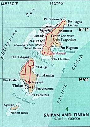
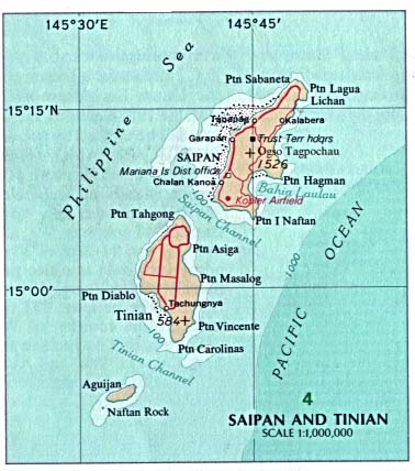
English: Map of the islands of Saipan and Tinian in the Northern Mariana Islands along the Marianas Trench (east of China and the Philippines). |
| Datum | |
| Bron |
Derived by cropping US Government (USNA) map: http://www.lib.utexas.edu/maps/australia/saipan_tinian_islands.jpg linked as being a US National Atlas (1970) map on related webpage: http://www.lib.utexas.edu/maps/northern_mariana_islands.html . |
| Auteur |
map:US Geological Survey |
| Andere versies |
 |
Licentie
The map is public domain, derived by User:Wikid77 from a USNA image (in JPEG format).
Deze afbeelding bevindt zich in het publiek domein omdat het materiaal bevat dat oorspronkelijk afkomstig is van de United States Geological Survey, een agentschap van de United States Department of the Interior. Voor meer informatie, zie het officiële USGS-auteursrechtenbeleid
|
Bestandsgeschiedenis
Klik op een datum/tijd om het bestand te zien zoals het destijds was.
| Datum/tijd | Miniatuur | Afmetingen | Gebruiker | Opmerking | |
|---|---|---|---|---|---|
| huidige versie | 7 mrt 2008 16:32 | | 290 × 410 (31 kB) | Wikid77 | initial upload |
Bestandsgebruik
Dit bestand wordt op de volgende pagina gebruikt:
Globaal bestandsgebruik
De volgende andere wiki's gebruiken dit bestand:
- Gebruikt op cs.wikipedia.org
- Gebruikt op el.wikipedia.org
- Gebruikt op en.wikipedia.org
- Gebruikt op eu.wikipedia.org
- Gebruikt op fa.wikipedia.org
- Gebruikt op ha.wikipedia.org
- Gebruikt op hi.wikipedia.org
- Gebruikt op id.wikipedia.org
- Gebruikt op it.wikipedia.org
- Gebruikt op ka.wikipedia.org
- Gebruikt op ml.wikipedia.org
- Gebruikt op ps.wikipedia.org
- Gebruikt op pt.wikipedia.org
- Gebruikt op sl.wikipedia.org
- Gebruikt op tr.wikipedia.org
- Gebruikt op uk.wikipedia.org
- Gebruikt op vi.wikipedia.org