
Bestand:Map of Danish Settlements in India (1620 - 1845).svg

Afmetingen van deze voorvertoning van het type PNG van dit SVG-bestand: 512 × 446 pixels Andere resoluties: 276 × 240 pixels | 551 × 480 pixels | 882 × 768 pixels | 1.176 × 1.024 pixels | 2.351 × 2.048 pixels.
Oorspronkelijk bestand (SVG-bestand, nominaal 512 × 446 pixels, bestandsgrootte: 162 kB)
| Dit is een bestand van Wikimedia Commons. Onderstaande beschrijving komt van de beschrijving van het bestand daar. |
.svg)
Beschrijving
| Beschrijving |
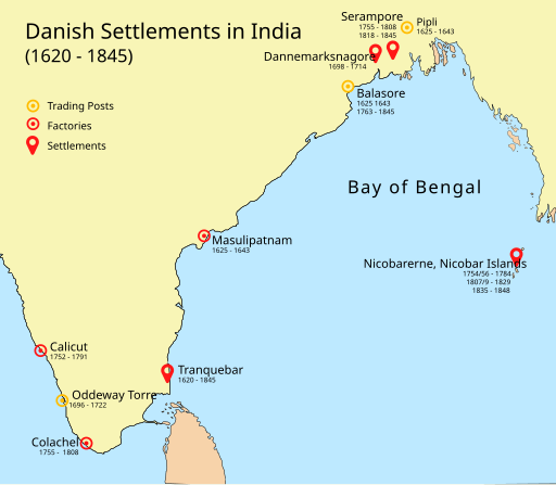
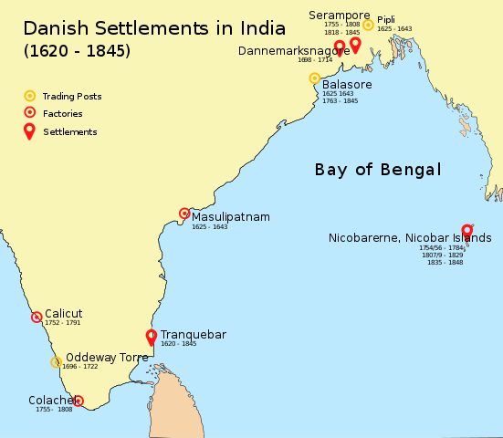
English: Map of Danish settlements and trading posts in India from 1620 - 1845 |
| Datum | |
| Bron | Created using illustrator |
| Auteur | Adondai |
| Dit bestand is beschikbaar onder Creative Commons CC0 1.0 Universele Public Domain Dedication. | |
| De persoon die een werk voorziet van deze licentie stelt dit werk beschikbaar aan het publieke domein door, voor zover dit wettelijk is toegestaan, afstand te doen van alle rechten op het werk in de zin van het auteursrecht, met inbegrip van alle aanverwante of naburige rechten. U kunt het werk kopiëren, aanpassen, distribueren en uitvoeren, ook voor commerciële doeleinden, zonder dat u daarvoor toestemming hoeft te vragen.
|
Licentie
| Ik, de auteursrechthebbende van dit werk, geef dit werk vrij in het publieke domein. Dit is wereldwijd van toepassing. In sommige landen is dit wettelijk niet mogelijk; in die gevallen geldt: Ik sta iedereen toe dit werk voor eender welk doel te gebruiken, zonder enige voorwaarden, tenzij zulke voorwaarden door de wet worden voorgeschreven. |
Bestandsgeschiedenis
Klik op een datum/tijd om het bestand te zien zoals het destijds was.
| Datum/tijd | Miniatuur | Afmetingen | Gebruiker | Opmerking | |
|---|---|---|---|---|---|
| huidige versie | 7 mei 2018 11:07 | | 512 × 446 (162 kB) | Adondai | {{subst:Upload marker added by en.wp UW}} {{Information |Description = {{en|Map of Danish settlements and trading posts in India from 1620 - 1845}} |Source = Created using illustrator |Date = 2018-05-07 |Author = Adondai }} {{cc-zero}} |
Bestandsgebruik
Dit bestand wordt op de volgende pagina gebruikt:
Globaal bestandsgebruik
De volgende andere wiki's gebruiken dit bestand:
- Gebruikt op ar.wikipedia.org
- Gebruikt op bn.wikipedia.org
- Gebruikt op de.wikipedia.org
- Gebruikt op en.wikipedia.org
- Gebruikt op en.wikivoyage.org
- Gebruikt op es.wikipedia.org
- Gebruikt op fr.wikipedia.org
- Gebruikt op he.wikipedia.org
- Gebruikt op id.wikipedia.org
- Gebruikt op is.wikipedia.org
- Gebruikt op it.wikipedia.org
- Gebruikt op ja.wikipedia.org
- Gebruikt op mt.wikipedia.org
- Gebruikt op vi.wikipedia.org
- Gebruikt op www.wikidata.org
- Gebruikt op wuu.wikipedia.org
- Gebruikt op zh.wikipedia.org
.svg)