
Bestand:Map of Maluku Islands-en.svg

Afmetingen van deze voorvertoning van het type PNG van dit SVG-bestand: 593 × 600 pixels Andere resoluties: 237 × 240 pixels | 474 × 480 pixels | 759 × 768 pixels | 1.012 × 1.024 pixels | 2.024 × 2.048 pixels | 1.363 × 1.379 pixels.
Oorspronkelijk bestand (SVG-bestand, nominaal 1.363 × 1.379 pixels, bestandsgrootte: 329 kB)
| Dit is een bestand van Wikimedia Commons. Onderstaande beschrijving komt van de beschrijving van het bestand daar. |
Beschrijving
| Beschrijving |
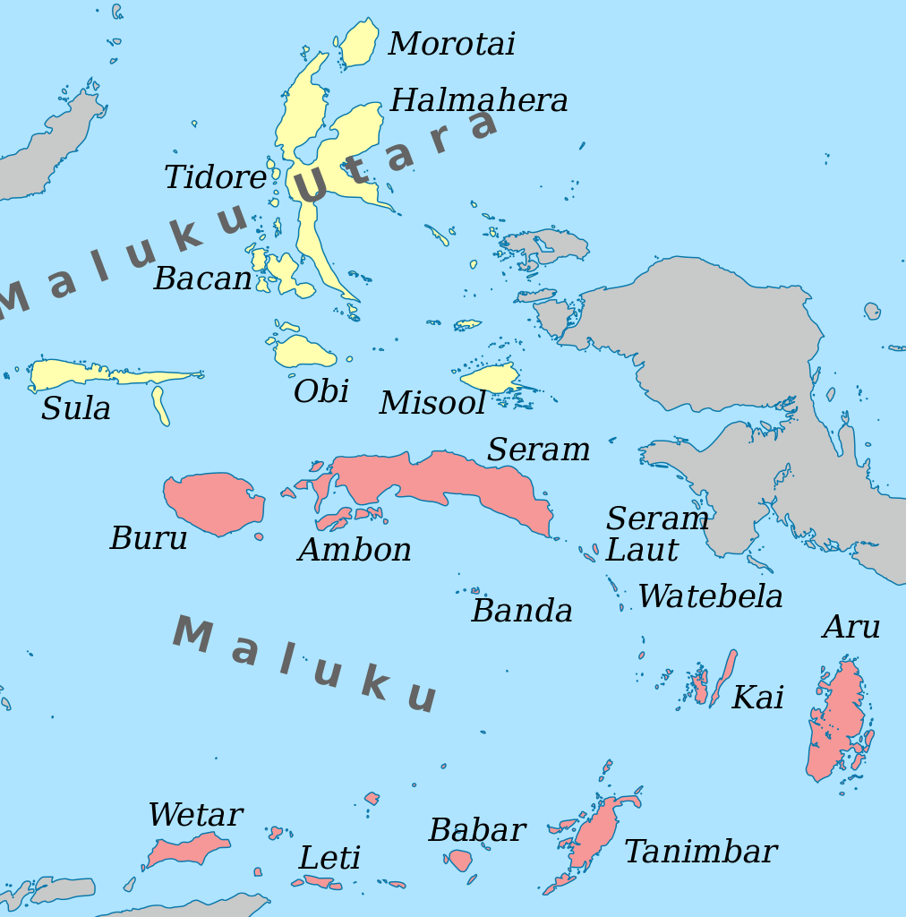
English: Map of the Maluku Islands. |
| Datum | |
| Bron | Eigen werk – self-made in Inkscape based on a 0-meter trace of SRTM30_PLUS data. |
| Auteur | Oona Räisänen (Mysid) |
Licentie
Ik, de auteursrechthebbende van dit werk, maak het hierbij onder de volgende licentie beschikbaar:
| Dit bestand is beschikbaar onder Creative Commons CC0 1.0 Universele Public Domain Dedication. | |
| De persoon die een werk voorziet van deze licentie stelt dit werk beschikbaar aan het publieke domein door, voor zover dit wettelijk is toegestaan, afstand te doen van alle rechten op het werk in de zin van het auteursrecht, met inbegrip van alle aanverwante of naburige rechten. U kunt het werk kopiëren, aanpassen, distribueren en uitvoeren, ook voor commerciële doeleinden, zonder dat u daarvoor toestemming hoeft te vragen.
|
Bestandsgeschiedenis
Klik op een datum/tijd om het bestand te zien zoals het destijds was.
| Datum/tijd | Miniatuur | Afmetingen | Gebruiker | Opmerking | |
|---|---|---|---|---|---|
| huidige versie | 22 okt 2012 10:00 | | 1.363 × 1.379 (329 kB) | Mysid | Atauro belongs to East Timor |
| 17 apr 2011 18:15 |  | 1.363 × 1.379 (372 kB) | Mysid | remove curved text (not working) | |
| 17 apr 2011 18:13 |  | 1.363 × 1.379 (372 kB) | Mysid | {{Information |Description ={{en|1=Map of the Maluku Islands.}} |Source ={{own}} - self-made in Inkscape. |Author =Mysid |Date =2010-04-17 |Permission = |other_versions = }} [[Cate |
Bestandsgebruik
Dit bestand wordt op de volgende pagina gebruikt:
Globaal bestandsgebruik
De volgende andere wiki's gebruiken dit bestand:
- Gebruikt op af.wikipedia.org
- Gebruikt op ar.wikipedia.org
- Gebruikt op el.wikipedia.org
- Gebruikt op en.wikipedia.org
- Gebruikt op eo.wikipedia.org
- Gebruikt op fa.wikipedia.org
- Gebruikt op ga.wikipedia.org
- Gebruikt op id.wikipedia.org
- Gebruikt op ilo.wikipedia.org
- Gebruikt op incubator.wikimedia.org
- Gebruikt op ja.wikipedia.org
- Gebruikt op min.wikipedia.org
- Gebruikt op ml.wikipedia.org
- Gebruikt op mrj.wikipedia.org
- Gebruikt op pnb.wikipedia.org
- Gebruikt op sw.wikipedia.org
- Gebruikt op tr.wikipedia.org
- Gebruikt op ur.wikipedia.org
- Gebruikt op war.wikipedia.org