
Bestand:Philadelphia Map, 1777 Philadelphia Campaign2.jpg

Grootte van deze voorvertoning: 356 × 598 pixels. Andere resoluties: 143 × 240 pixels | 285 × 480 pixels | 457 × 768 pixels | 609 × 1.024 pixels | 1.218 × 2.048 pixels | 10.766 × 18.097 pixels.
Oorspronkelijk bestand (10.766 × 18.097 pixels, bestandsgrootte: 25,54 MB, MIME-type: image/jpeg)
| Dit is een bestand van Wikimedia Commons. Onderstaande beschrijving komt van de beschrijving van het bestand daar. |
Beschrijving
| Let op | Sommige browsers kunnen mogelijk problemen hebben om deze afbeelding op ware grootte weer te geven: Deze afbeelding heeft een ongebruikelijk hoog aantal pixels waardoor de browser de afbeelding mogelijk niet laadt of zelfs vastloopt. |
|---|
| Beschrijving |
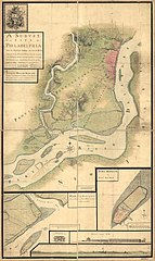
English: A survey of the city of Philadelphia and its environs shewing the several works constructed by His Majesty's troops, under the command of Sir William Howe, since their possession of that city 26th. September 1777, comprehending likewise the attacks against Fort Mifflin on Mud Island, and until it's reduction, 16th November 1777. |
||
| Datum | |||
| Bron | Library of Congress | ||
| Auteur |
Contributor Names:
|
||
| Andere versies |
|


Licentie
|
Dit werk bevindt zich in het publiek domein in landen en gebieden waar de auteursrechttermijn het leven van de auteur plus 70 jaar of minder is. Dit werk bevindt zich in het publiek domein in de Verenigde Staten omdat het gepubliceerd werd (of geregistreerd bij de U.S. Copyright Office) voor 1 januari 1929. | |
| Van dit bestand is vastgesteld dat er geen bekende auteursrechtaanspraken op rusten, alle aanverwante en naburige rechten daarbij inbegrepen. | |
Bestandsgeschiedenis
Klik op een datum/tijd om het bestand te zien zoals het destijds was.
| Datum/tijd | Miniatuur | Afmetingen | Gebruiker | Opmerking | |
|---|---|---|---|---|---|
| huidige versie | 12 jan 2021 22:15 | | 10.766 × 18.097 (25,54 MB) | Gwillhickers | Uploaded a work by Contributor Names Nicole, Pierre, -1784. Montrésor, John, 1736-1799. Created / Published 1777 from [https://www.loc.gov/item/gm71000933/ '''Library of Congress'''] with UploadWizard |
Bestandsgebruik
Dit bestand wordt op de volgende pagina gebruikt:
Globaal bestandsgebruik
De volgende andere wiki's gebruiken dit bestand:
- Gebruikt op en.wikipedia.org