
Bestand:Plan tramway reims.png
Grootte van deze voorvertoning: 271 × 600 pixels. Andere resoluties: 108 × 240 pixels | 217 × 480 pixels | 1.000 × 2.213 pixels.
Oorspronkelijk bestand (1.000 × 2.213 pixels, bestandsgrootte: 2,33 MB, MIME-type: image/png)
| Dit is een bestand van Wikimedia Commons. Onderstaande beschrijving komt van de beschrijving van het bestand daar. |
Beschrijving
| Beschrijving |
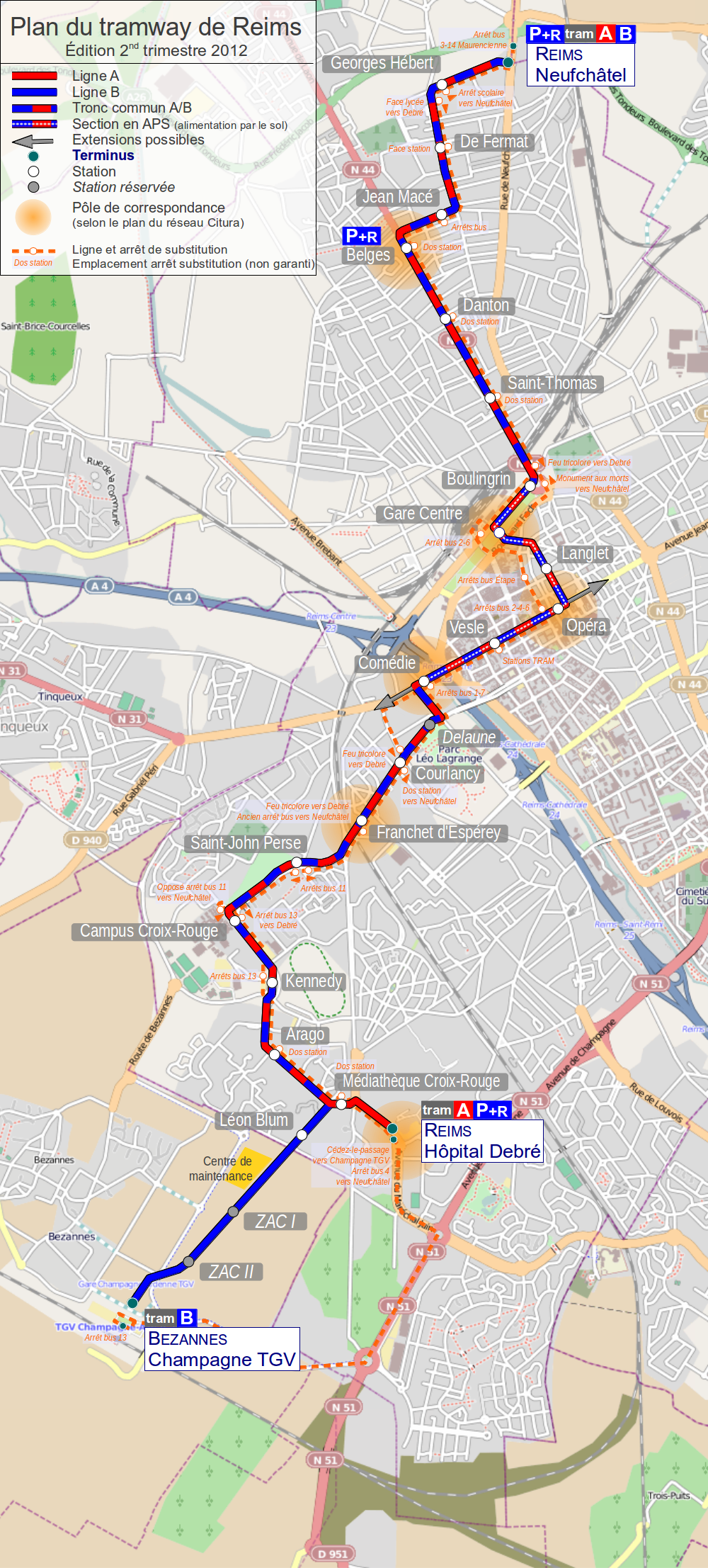
English: Map of tramway in Rheims France
Français : Plan du tramway de Reims, France |
| Datum | |
| Bron | Eigen werk. Background map: © OpenStreetMap and contributors, CC BY-SA. |
| Auteur | Daiima |
Licentie
Dit bestand is gelicenseerd onder de Creative Commons-licentie Naamsvermelding-Gelijk delen 2.0 Unported
- De gebruiker mag:
- Delen – het werk kopiëren, verspreiden en doorgeven
- Remixen – afgeleide werken maken
- Onder de volgende voorwaarden:
- naamsvermelding – U moet op een gepaste manier aan naamsvermelding doen, een link naar de licentie geven, en aangeven of er wijzigingen in het werk zijn aangebracht. U mag dit op elke redelijke manier doen, maar niet zodanig dat de indruk wordt gewekt dat de licentiegever instemt met uw werk of uw gebruik van zijn werk.
- Gelijk delen – Als u het werk heeft geremixt, veranderd, of erop heeft voortgebouwd, moet u het gewijzigde materiaal verspreiden onder dezelfde licentie als het oorspronkelijke werk, of een daarmee compatibele licentie.
Bestandsgeschiedenis
Klik op een datum/tijd om het bestand te zien zoals het destijds was.
| Datum/tijd | Miniatuur | Afmetingen | Gebruiker | Opmerking | |
|---|---|---|---|---|---|
| huidige versie | 2 apr 2012 22:43 | | 1.000 × 2.213 (2,33 MB) | Daiima | Visiblement l'upload s'est mal déroulé, nouvelle tentative |
| 2 apr 2012 22:39 |  | 1.000 × 2.213 (2,33 MB) | Daiima | Ajout ligne substitution | |
| 29 aug 2011 15:50 |  | 695 × 1.538 (1,31 MB) | Daiima | Mise à jour rentrée 2011 ligne B jusqu'à Neufchâtel | |
| 7 feb 2011 20:16 |  | 695 × 1.538 (3,06 MB) | Daiima | stations projetées sur bezannes | |
| 29 dec 2010 00:12 |  | 695 × 1.538 (3,06 MB) | Daiima | updates | |
| 12 okt 2010 17:36 |  | 695 × 1.538 (3,06 MB) | Daiima | + Centre de Maintenance | |
| 12 okt 2010 14:15 |  | 695 × 1.538 (3,06 MB) | Daiima | + Park-and-Ride | |
| 12 okt 2010 14:08 |  | 695 × 1.538 (3,06 MB) | Daiima | {{Information |Description={{en|1=Map of tramway in Rheims France}} {{fr|1=Plan du tramway de Reims, France}} |Source={{own}} |Author=Daiima |Date=2010/10/12 |Permission= |other_versions= }} Category:Public transport maps of Reims |
Bestandsgebruik
Dit bestand wordt op de volgende pagina gebruikt:
Globaal bestandsgebruik
De volgende andere wiki's gebruiken dit bestand:
- Gebruikt op als.wikipedia.org
- Gebruikt op de.wikipedia.org
- Gebruikt op eo.wikipedia.org
- Gebruikt op fr.wikipedia.org
- Gebruikt op hu.wikipedia.org
- Gebruikt op it.wikipedia.org
- Gebruikt op ja.wikipedia.org
- Gebruikt op pl.wikipedia.org
- Gebruikt op ru.wikipedia.org
- Gebruikt op uk.wikipedia.org
- Gebruikt op www.wikidata.org