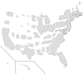
Bestand:Population Scaled US Map.svg

Pagina-inhoud wordt niet ondersteund in andere talen.
Uit Wikipedia, de vrije encyclopedie

Oorspronkelijk bestand(SVG-bestand, nominaal 407 × 345 pixels, bestandsgrootte: 42 kB)


Beschrijving

Beschrijving
English: This request originated from the Illustration workshop, and was solved mathematically using the data at the linked article. By definition, the population density is the population divided by area, or:
or, equivalently,

We want to resize each state according to its population, so each state's new area will be defined by a new (constant) population density, :

We can substitute for in the above expression to get:

This means the new area is simply the existing area multiplied by an areal scaling factor . Since area is the product of two dimensions, we can apply an equal scaling factor in each dimension (which is what the SVG expects) by taking the square root of the areal scaling factor:

I took the new population density to be equal to the 2013 population density of New Jersey, 1,210.1 persons per square mile, which in essence normalizes the scaling factor to New Jersey. For instance, California has a 2013 population density of 246.1 persons per square mile, so:

That means that I apply a scaling transformation factor of 0.451 to the California SVG object in each (x,y) dimension. When all is said and done, though, I had to end up translating most of the state SVG objects as well, so it ended up being a matrix transform (scaling + translation). When the population and/or land areas update, the updated data could be used to adjust the scaling factors in the SVG directly without having to go through a graphical editor.
Datum
Bron Eigen werk, using vector source linked below.
Auteur Mliu92
Andere versies Dit bestand is afgeleid van: Blank US Map.svg

Licentie

Ik, de auteursrechthebbende van dit werk, maak het hierbij onder de volgende licentie beschikbaar:
w:nl:Creative Commons
naamsvermelding Gelijk delen
Dit bestand is gelicenseerd onder de Creative Commons Naamsvermelding-GelijkDelen 4.0 Internationaal licentie.
De gebruiker mag:
  • Delen – het werk kopiëren, verspreiden en doorgeven
  • Remixen – afgeleide werken maken
Onder de volgende voorwaarden:
  • naamsvermelding – U moet op een gepaste manier aan naamsvermelding doen, een link naar de licentie geven, en aangeven of er wijzigingen in het werk zijn aangebracht. U mag dit op elke redelijke manier doen, maar niet zodanig dat de indruk wordt gewekt dat de licentiegever instemt met uw werk of uw gebruik van zijn werk.
  • Gelijk delen – Als u het werk heeft geremixt, veranderd, of erop heeft voortgebouwd, moet u het gewijzigde materiaal verspreiden onder dezelfde licentie als het oorspronkelijke werk, of een daarmee compatibele licentie.

Bijschriften

Beschrijf in één regel wat dit bestand voorstelt

Items getoond in dit bestand

beeldt af

Bestandsgeschiedenis

Klik op een datum/tijd om het bestand te zien zoals het destijds was.

Datum/tijdMiniatuurAfmetingenGebruikerOpmerking
huidige versie16 sep 2017 13:56Miniatuurafbeelding voor de versie van 16 sep 2017 13:56407 × 345 (42 kB)MadshurtieUpdated with new boundaries from File:Blank USA, w territories.svg and File:Blank US Map (states only).svg. Removed outlines because they're ugly and got scaled proportional to population density, which isn't the most useful value.
14 sep 2017 15:15Miniatuurafbeelding voor de versie van 14 sep 2017 15:15395 × 349 (68 kB)MadshurtieNo idea why this isn't rendering properly on wikipedia.
14 sep 2017 15:11Miniatuurafbeelding voor de versie van 14 sep 2017 15:11395 × 349 (68 kB)MadshurtieFound the scales on the original document File:Map of USA with state names.svg to get slightly more accurate scaling factors. I have adjusted Hawaii as well.
14 sep 2017 14:50Miniatuurafbeelding voor de versie van 14 sep 2017 14:50395 × 349 (68 kB)MadshurtieDidn't upload properly
14 sep 2017 14:41Miniatuurafbeelding voor de versie van 14 sep 2017 14:41395 × 349 (68 kB)MadshurtieAlaska by population shouldn't be smaller than Wyoming and North Dakota. Alaska was too small because the source image File:Blank US Map.svg had a scaled-down Alaska. I have measured the pixel area of the source Alaska and calculated its ratio to...
5 jan 2016 22:18Miniatuurafbeelding voor de versie van 5 jan 2016 22:18395 × 349 (68 kB)Mliu92Fixed mixup between WY/CO – thanks!
22 sep 2015 18:04Miniatuurafbeelding voor de versie van 22 sep 2015 18:04395 × 349 (68 kB)Mliu92User created page with UploadWizard

Dit bestand wordt op de volgende pagina gebruikt:

Globaal bestandsgebruik

De volgende andere wiki's gebruiken dit bestand:

Metadata