
Bestand:Provinces of Cambodia loss to Thailand during Franco-Thai War.png

Oorspronkelijk bestand (1.200 × 900 pixels, bestandsgrootte: 187 kB, MIME-type: image/png)
| Dit is een bestand van Wikimedia Commons. Onderstaande beschrijving komt van de beschrijving van het bestand daar. |
This file may not have the correct information on its copyright status.
The reason given by the user who added this tag is: File has incomplete source information; it's obviously based on other CC-licensed maps here on Commons.
Notify the uploader with:
Items tagged with this template are sorted into Category:Items with disputed copyright information.
|
Beschrijving
| Beschrijving |
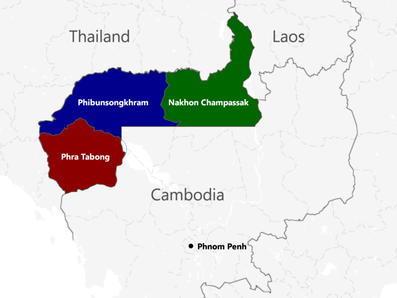
English: The territories of Cambodia and Laos annexed by Thailand in 1941, according to "ประกาศ ใช้อนุสัญญาสันติภาพและบรรดาภาคผนวก ระหว่างไทยและฝรั่งเศส", regrouped as in the map. |
| Datum | |
| Bron | Eigen werk |
| Auteur | Murashel, edited by: Thanyakij |
Licentie
- De gebruiker mag:
- Delen – het werk kopiëren, verspreiden en doorgeven
- Remixen – afgeleide werken maken
- Onder de volgende voorwaarden:
- naamsvermelding – U moet op een gepaste manier aan naamsvermelding doen, een link naar de licentie geven, en aangeven of er wijzigingen in het werk zijn aangebracht. U mag dit op elke redelijke manier doen, maar niet zodanig dat de indruk wordt gewekt dat de licentiegever instemt met uw werk of uw gebruik van zijn werk.
- Gelijk delen – Als u het werk heeft geremixt, veranderd, of erop heeft voortgebouwd, moet u het gewijzigde materiaal verspreiden onder dezelfde licentie als het oorspronkelijke werk, of een daarmee compatibele licentie.
Bestandsgeschiedenis
Klik op een datum/tijd om het bestand te zien zoals het destijds was.
| Datum/tijd | Miniatuur | Afmetingen | Gebruiker | Opmerking | |
|---|---|---|---|---|---|
| huidige versie | 23 jul 2017 06:48 | | 1.200 × 900 (187 kB) | Aquapatinth | change - southern border of Phibulsongkhram and Nakhon Champassak Provinces to the 13.5th parallel and - southeastern border of Phibulsongkhram to meridian line from the point which border line between Siem Reap and Battanbang Province met Tonle Sap.... |
| 16 feb 2016 09:19 |  | 1.001 × 921 (303 kB) | Xufanc | corrected spelling | |
| 12 feb 2016 07:49 |  | 1.001 × 921 (303 kB) | Xufanc | Added missing part of Nakhon Champassak Province | |
| 25 sep 2014 19:46 |  | 1.000 × 903 (308 kB) | RJFF | Somehow the revert did not work. | |
| 25 sep 2014 19:38 |  | 1.000 × 903 (308 kB) | RJFF | Reverted to version as of 17:36, 25 September 2014 | |
| 25 sep 2014 19:37 |  | 1.000 × 903 (308 kB) | RJFF | Reverted to version as of 18:43, 30 December 2013 | |
| 25 sep 2014 19:36 |  | 1.000 × 903 (308 kB) | RJFF | Reverted to version as of 18:43, 30 December 2013: The other version seems to be more accurate, see [http://daravireak.files.wordpress.com/2012/10/map_thailand_3province_indochine.png here], [http://www.websitesrcg.com/border/maps/indochina-1942.jpg he... | |
| 9 feb 2014 17:32 |  | 1.000 × 903 (321 kB) | Murashel | In Peace treaty in Tokyo Thais gain territory of Koh Kong. | |
| 30 dec 2013 20:43 |  | 1.000 × 903 (308 kB) | Derkommander0916 | Thailand never took Koh Kong and Pursat Refer this: http://www.geographicus.com/P/AntiqueMap/Thailand-japanese-1943 | |
| 9 jun 2013 17:01 |  | 1.000 × 903 (321 kB) | Murashel | User created page with UploadWizard |
Bestandsgebruik
Dit bestand wordt op de volgende pagina gebruikt:
Globaal bestandsgebruik
De volgende andere wiki's gebruiken dit bestand:
- Gebruikt op ca.wikipedia.org
- Gebruikt op en.wikipedia.org
- Gebruikt op es.wikipedia.org
- Gebruikt op fa.wikipedia.org
- Gebruikt op fr.wikipedia.org
- Gebruikt op he.wikipedia.org
- Gebruikt op it.wikipedia.org
- Gebruikt op ja.wikipedia.org
- Gebruikt op km.wikipedia.org
- Gebruikt op lo.wikipedia.org
- Gebruikt op pl.wikipedia.org
- Gebruikt op ru.wikipedia.org
- Gebruikt op th.wikipedia.org
- Gebruikt op vi.wikipedia.org
- Gebruikt op zh.wikipedia.org