
Bestand:SRTS map PNG.png
Grootte van deze voorvertoning: 305 × 600 pixels. Andere resoluties: 122 × 240 pixels | 420 × 826 pixels.
Oorspronkelijk bestand (420 × 826 pixels, bestandsgrootte: 89 kB, MIME-type: image/png)
| Dit is een bestand van Wikimedia Commons. Onderstaande beschrijving komt van de beschrijving van het bestand daar. |
Beschrijving
| Beschrijving |
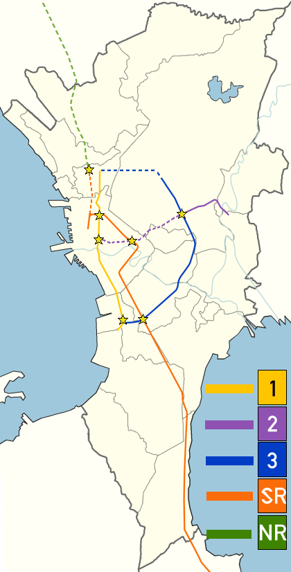
English: Strong Republic Transit System, was launched in 2003 to integrate rapid transit and railway lines in and around Metro Manila. This blank Metro Manila map has been used to create the map [1]. |
| Datum | |
| Bron | Eigen werk |
| Auteur | Utnog La |
![[1]](https://en.wikipedia.org/wiki/File:BlankMap-MetroManila.png)
Licentie
Ik, de auteursrechthebbende van dit werk, maak het hierbij onder de volgende licentie beschikbaar:
Dit bestand is gelicenseerd onder de Creative Commons-licentie Naamsvermelding-Gelijk delen 3.0 Unported
- De gebruiker mag:
- Delen – het werk kopiëren, verspreiden en doorgeven
- Remixen – afgeleide werken maken
- Onder de volgende voorwaarden:
- naamsvermelding – U moet op een gepaste manier aan naamsvermelding doen, een link naar de licentie geven, en aangeven of er wijzigingen in het werk zijn aangebracht. U mag dit op elke redelijke manier doen, maar niet zodanig dat de indruk wordt gewekt dat de licentiegever instemt met uw werk of uw gebruik van zijn werk.
- Gelijk delen – Als u het werk heeft geremixt, veranderd, of erop heeft voortgebouwd, moet u het gewijzigde materiaal verspreiden onder dezelfde licentie als het oorspronkelijke werk, of een daarmee compatibele licentie.
Bestandsgeschiedenis
Klik op een datum/tijd om het bestand te zien zoals het destijds was.
| Datum/tijd | Miniatuur | Afmetingen | Gebruiker | Opmerking | |
|---|---|---|---|---|---|
| huidige versie | 19 jul 2015 17:02 | | 420 × 826 (89 kB) | Abante86 | Part of PNR's orange line was stylized differently (Solis, C3 etc. never offered services) Purple line should be a dashed line. SRTS article should be about the initial program (which situation after the initial situation would be appropiate?? best to... |
| 18 jun 2014 03:06 |  | 420 × 826 (90 kB) | PhilippineRevolution | Purple line should have been solid as later SRTS maps showed it in solid lines | |
| 23 okt 2011 05:09 |  | 420 × 826 (105 kB) | Utnog La | corrections: green line | |
| 23 okt 2011 01:40 |  | 420 × 826 (106 kB) | Utnog La | details (yellow) | |
| 23 okt 2011 01:28 |  | 420 × 826 (106 kB) | Utnog La | purple line should have been dashed | |
| 22 okt 2011 23:40 |  | 420 × 826 (106 kB) | Utnog La | corrected orange line | |
| 22 okt 2011 23:37 |  | 420 × 826 (106 kB) | Utnog La | correction | |
| 22 okt 2011 23:35 |  | 420 × 826 (106 kB) | Utnog La |
Bestandsgebruik
Dit bestand wordt op de volgende pagina gebruikt:
Globaal bestandsgebruik
De volgende andere wiki's gebruiken dit bestand:
- Gebruikt op en.wikipedia.org
- Gebruikt op ja.wikipedia.org
- Gebruikt op th.wikipedia.org