
Bestand:Six Day War Territories.png
Six_Day_War_Territories.png (398 × 599 pixels, bestandsgrootte: 53 kB, MIME-type: image/png)
| Dit is een bestand van Wikimedia Commons. Onderstaande beschrijving komt van de beschrijving van het bestand daar. |
Beschrijving

|
Bestand:Six Day War Terrritories.svg is een vectorversie van dit bestand. Indien niet van slechtere kwaliteit dient deze gebruikt te worden in plaats van deze rasterafbeelding.
File:Six Day War Territories.png → File:Six Day War Terrritories.svg
Zie Help:SVG voor meer informatie. |
 |
| Beschrijving |
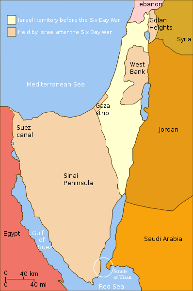
English: Changes in political boundaries following the Six Day war. In yellow: Israel within the "Green Line" borders (per 1949 ceasefire agreements); In light maroon: Territories Israel seized during the war and maintained its control over them in the aftermath of the war. The Straits of Tiran are circled, between the Gulf of Aqaba/Eilat, and the Red Sea. |
| Datum | Datum onbekend |
| Bron | Yom Kippur War map.svg |
| Auteur | User:Ling.Nut |
| Andere versies |
[]
|


.png)


"Self-made line drawing of a map of Israel's territories before and after the Six Day War. Author: User:Ling.Nut Source of line drawing: File:Yom Kippur War map.svg authored by User:Raul654, sourced to now-deleted image Image:Jom kippur war.jpg, which was originally uploaded to the polish Wikipedia at http://pl.wikipedia.org/wiki/Grafika:Jom_kippur_war.jpg -- Ministerstwo Spraw Zagranicznych Izraela, za zgodÄ… Ambasady Izraela w Polsce. -- Ministry of Foreign Affairs of Israel, with the permission of Israel Embassy in Poland"
Licentie
- De gebruiker mag:
- Delen – het werk kopiëren, verspreiden en doorgeven
- Remixen – afgeleide werken maken
- Onder de volgende voorwaarden:
- naamsvermelding – U moet op een gepaste manier aan naamsvermelding doen, een link naar de licentie geven, en aangeven of er wijzigingen in het werk zijn aangebracht. U mag dit op elke redelijke manier doen, maar niet zodanig dat de indruk wordt gewekt dat de licentiegever instemt met uw werk of uw gebruik van zijn werk.
- Gelijk delen – Als u het werk heeft geremixt, veranderd, of erop heeft voortgebouwd, moet u het gewijzigde materiaal verspreiden onder dezelfde licentie als het oorspronkelijke werk, of een daarmee compatibele licentie.
Bestandsgeschiedenis
Klik op een datum/tijd om het bestand te zien zoals het destijds was.
| Datum/tijd | Miniatuur | Afmetingen | Gebruiker | Opmerking | |
|---|---|---|---|---|---|
| huidige versie | 11 nov 2010 23:32 | | 398 × 599 (53 kB) | 99of9 | Reverted to version as of 07:04, 25 July 2010. Both POV versions should be at different locations, marked with POV and linked. |
| 8 nov 2010 13:06 |  | 398 × 599 (52 kB) | Supreme Deliciousness | Israeli territory before the Six day war is the same as after the Six day war. | |
| 25 jul 2010 09:04 |  | 398 × 599 (53 kB) | Ling.Nut | {{Information |Description={{en|1=Israeli territories before and after the Six Day War. The Straits of Tiran are circled, between the Gulf of Aqaba, and the Red Sea.}} |Source=Yom Kippur War map.svg |Author=User:Ling.Nut |Date= |Permission= |other_ver |
Bestandsgebruik
Dit bestand wordt op de volgende pagina gebruikt:
Globaal bestandsgebruik
De volgende andere wiki's gebruiken dit bestand:
- Gebruikt op ca.wikipedia.org
- Gebruikt op he.wikipedia.org
- Gebruikt op ug.wikipedia.org
- Gebruikt op www.wikidata.org