
Bestand:WW2-Holocaust-Europe-2007Borders.png
Oorspronkelijk bestand (1.310 × 1.090 pixels, bestandsgrootte: 597 kB, MIME-type: image/png)
| Dit is een bestand van Wikimedia Commons. Onderstaande beschrijving komt van de beschrijving van het bestand daar. |
Beschrijving
| Beschrijving |
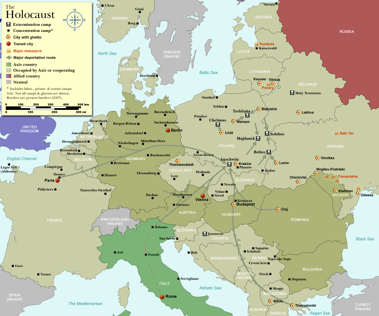
Map of the Holocaust in Europe during World War II, 1939-1945.
Übersetzung der "Notes" bis hierher: |
| Datum | |
| Bron | Self-made by User:Dna-Dennis, using information from USHMM & Wikipedia. |
| Auteur | User:Dna-Dennis |
| Toestemming (Hergebruik van dit bestand) |
CC, see below. The map is completely unrestricted for any Wikipedia/Wikimedia project. |
| Andere versies |
[]
|


.png)


.png)


|
Deze kaartafbeelding zou opnieuw moeten worden aangemaakt als een SVG-bestand door vectorafbeeldingen te gebruiken. Dit heeft een aantal voordelen; zie Commons:Media for cleanup voor meer informatie. Als er een SVG-formaat van deze afbeelding bestaat, dan deze graag uploaden. Nadat u dit heeft gedaan, gelieve dit sjabloon te vervangen door het sjabloon {{vector version available|nieuwe bestandsnaam.svg}} op deze afbeeldingspagina.
|
Licentie
- De gebruiker mag:
- Delen – het werk kopiëren, verspreiden en doorgeven
- Remixen – afgeleide werken maken
- Onder de volgende voorwaarden:
- naamsvermelding – U moet op een gepaste manier aan naamsvermelding doen, een link naar de licentie geven, en aangeven of er wijzigingen in het werk zijn aangebracht. U mag dit op elke redelijke manier doen, maar niet zodanig dat de indruk wordt gewekt dat de licentiegever instemt met uw werk of uw gebruik van zijn werk.
Bestandsgeschiedenis
Klik op een datum/tijd om het bestand te zien zoals het destijds was.
| Datum/tijd | Miniatuur | Afmetingen | Gebruiker | Opmerking | |
|---|---|---|---|---|---|
| huidige versie | 2 nov 2009 20:49 | | 1.310 × 1.090 (597 kB) | Flying Saucer | Vaivara location corrected |
| 17 dec 2007 12:40 |  | 1.310 × 1.090 (767 kB) | Dna-webmaster~commonswiki | == Summary == {{Information |Description=Map of the Holocaust in Europe during World War II, 1939-1945. <br> This map shows all extermination camps (or ''death camps''), most major concentration camps, labor camps, prison camps, ghettos, major deportation |
Bestandsgebruik
Dit bestand wordt op de volgende pagina gebruikt:
Globaal bestandsgebruik
De volgende andere wiki's gebruiken dit bestand:
- Gebruikt op bn.wikipedia.org
- Gebruikt op cs.wikipedia.org
- Gebruikt op en.wikipedia.org
- Gebruikt op es.wikipedia.org
- Gebruikt op it.wikipedia.org
- Gebruikt op ko.wikipedia.org
- Gebruikt op no.wikipedia.org
- Gebruikt op pt.wikipedia.org
- Gebruikt op th.wikipedia.org
- Gebruikt op tr.wikipedia.org
- Gebruikt op uk.wikipedia.org