
Bestand:Wfm vancouver island.jpg

Grootte van deze voorvertoning: 800 × 593 pixels. Andere resoluties: 320 × 237 pixels | 640 × 474 pixels | 1.024 × 758 pixels | 1.280 × 948 pixels.
Oorspronkelijk bestand (1.280 × 948 pixels, bestandsgrootte: 317 kB, MIME-type: image/jpeg)
| Dit is een bestand van Wikimedia Commons. Onderstaande beschrijving komt van de beschrijving van het bestand daar. |
Beschrijving
| Beschrijving |
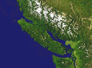
English: Vancouver Island in western Canada. Satellite picture. NASA blue pearl data |
| Datum | 9 april 2006 (uploaddatum) |
| Bron | Satellite imagery taken from NASA World Wind software (by screenshot) |
| Auteur | NASA |
Licentie
| Deze afbeelding bevindt zich in het publiek domein omdat het een screenshot is van NASA’s software World Wind die gebruik maakt van een publiek domein-laag, zoals Blue Marble, MODIS, Landsat, SRTM, USGS of GLOBE.
|
 |
Bestandsgeschiedenis
Klik op een datum/tijd om het bestand te zien zoals het destijds was.
| Datum/tijd | Miniatuur | Afmetingen | Gebruiker | Opmerking | |
|---|---|---|---|---|---|
| huidige versie | 9 apr 2006 18:19 | | 1.280 × 948 (317 kB) | Finlay McWalter | Vancouver Island in western Canada NASA blue pearl data, collecter using NASA World Wind. {{PD-USGov-NASA}} Category:Satellite images of islands Category:Satellite pictures of Canada |
Bestandsgebruik
Dit bestand wordt op de volgende pagina gebruikt:
Globaal bestandsgebruik
De volgende andere wiki's gebruiken dit bestand:
- Gebruikt op af.wikipedia.org
- Gebruikt op ba.wikipedia.org
- Gebruikt op ceb.wikipedia.org
- Gebruikt op de.wikipedia.org
- Gebruikt op eo.wikipedia.org
- Gebruikt op es.wikipedia.org
- Gebruikt op et.wikipedia.org
- Gebruikt op fi.wikipedia.org
- Gebruikt op ru.wikipedia.org
- Gebruikt op vi.wikipedia.org