
Bestand:Yuba river watershed.png
Grootte van deze voorvertoning: 800 × 583 pixels. Andere resoluties: 320 × 233 pixels | 640 × 466 pixels | 936 × 682 pixels.
Oorspronkelijk bestand (936 × 682 pixels, bestandsgrootte: 33 kB, MIME-type: image/png)
| Dit is een bestand van Wikimedia Commons. Onderstaande beschrijving komt van de beschrijving van het bestand daar. |
| Beschrijving |
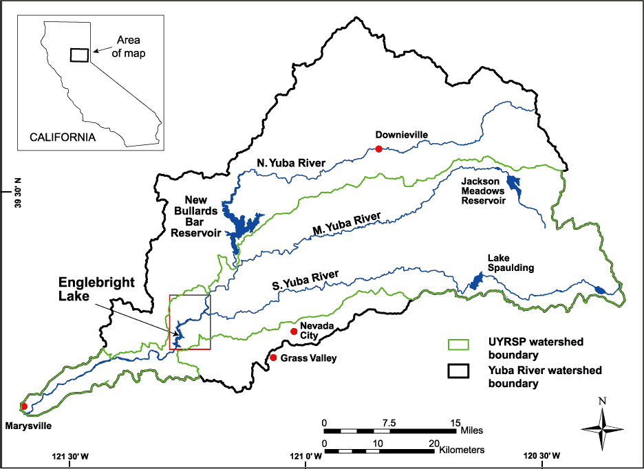
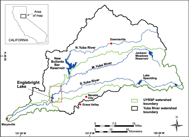
English: Map of the watershed of the Yuba River in Nevada and Yuba Counties, California, USA. Map drawn by the U.S. Geological Service (USGS) for bathymetric and geophysical surveys of Englebright Lake, which is impounded by Englebright Dam on the Yuba River. The black borders encompass the entire watershed of the three forks of the Yuba River. The green borders encompass the limits of the USGS Upper Yuba River Watershed Studies Program (UYRSP) area. Map slightly reworked by contributor from source map and converted to PNG. |
|||
| Locatie | not specified or unknown | |||
| Datum | not specified or unknown | |||
| Bron |
U.S. Geological Survey, Western Region Coastal and Marine Geology Image page Image description page USGS home page |
|||
| Auteur | U.S. Geological Survey, artist not specified or unknown | |||
| Toestemming (Hergebruik van dit bestand) |
|
Bestandsgeschiedenis
Klik op een datum/tijd om het bestand te zien zoals het destijds was.
| Datum/tijd | Miniatuur | Afmetingen | Gebruiker | Opmerking | |
|---|---|---|---|---|---|
| huidige versie | 5 mei 2007 18:02 | | 936 × 682 (33 kB) | DanMS | Uploaded new version to correct problems with transparent color. |
| 5 mei 2007 17:59 |  | 936 × 682 (33 kB) | DanMS | {{Information | Description = {{en|Map of the watershed of the Yuba River in Nevada and Yuba Counties, California, USA. Map drawn by the U.S. Geological Service (USGS) for bathymetric and geophysical surveys of Englebright Lake, which is impounded by E |
Bestandsgebruik
Dit bestand wordt op de volgende pagina gebruikt:
Globaal bestandsgebruik
De volgende andere wiki's gebruiken dit bestand:
- Gebruikt op de.wikipedia.org
- Gebruikt op en.wikipedia.org
- Gebruikt op fr.wikipedia.org
- Gebruikt op www.wikidata.org