
Bestand:Geologic map SE England & Channel EN.svg

Afmetingen van deze voorvertoning van het type PNG van dit SVG-bestand: 800 × 518 pixels Andere resoluties: 320 × 207 pixels | 640 × 415 pixels | 1.024 × 663 pixels | 1.280 × 829 pixels | 2.560 × 1.658 pixels | 1.374 × 890 pixels.
Oorspronkelijk bestand (SVG-bestand, nominaal 1.374 × 890 pixels, bestandsgrootte: 1,65 MB)
| Dit is een bestand van Wikimedia Commons. Onderstaande beschrijving komt van de beschrijving van het bestand daar. |
Beschrijving
| Beschrijving |
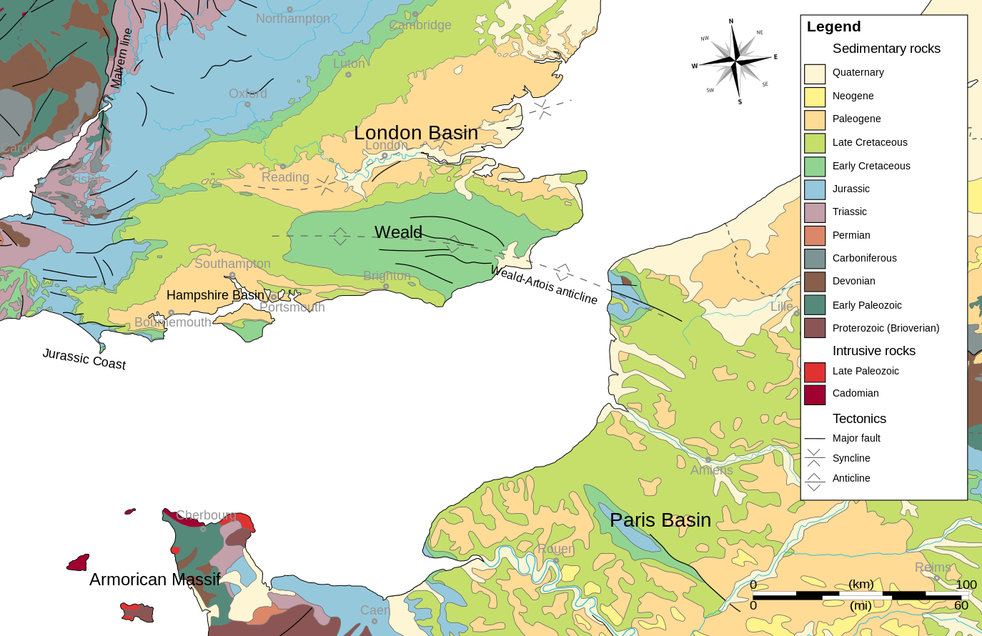
English: Geologic map of southeastern England, the English Channel and Pays-de-Calais.
Based on:
|
| Datum | |
| Bron | Eigen werk |
| Auteur | Woudloper |
Licentie
Ik, de auteursrechthebbende van dit werk, maak het hierbij onder de volgende licenties beschikbaar:

|
Toestemming wordt verleend voor het kopiëren, verspreiden en/of wijzigen van dit document onder de voorwaarden van de GNU-licentie voor vrije documentatie, versie 1.2 of enige latere versie als gepubliceerd door de Free Software Foundation; zonder Invariant Sections, zonder Front-Cover Texts, en zonder Back-Cover Texts. Een kopie van de licentie is opgenomen in de sectie GNU-licentie voor vrije documentatie. |
Dit bestand is gelicenseerd onder de Creative Commons-licenties Naamsvermelding-Gelijk delen 3.0 Unported, 2.5 Algemeen, 2.0 Algemeen en 1.0 Algemeen.
- De gebruiker mag:
- Delen – het werk kopiëren, verspreiden en doorgeven
- Remixen – afgeleide werken maken
- Onder de volgende voorwaarden:
- naamsvermelding – U moet op een gepaste manier aan naamsvermelding doen, een link naar de licentie geven, en aangeven of er wijzigingen in het werk zijn aangebracht. U mag dit op elke redelijke manier doen, maar niet zodanig dat de indruk wordt gewekt dat de licentiegever instemt met uw werk of uw gebruik van zijn werk.
- Gelijk delen – Als u het werk heeft geremixt, veranderd, of erop heeft voortgebouwd, moet u het gewijzigde materiaal verspreiden onder dezelfde licentie als het oorspronkelijke werk, of een daarmee compatibele licentie.
U mag zelf één van de licenties kiezen.
Bestandsgeschiedenis
Klik op een datum/tijd om het bestand te zien zoals het destijds was.
| Datum/tijd | Miniatuur | Afmetingen | Gebruiker | Opmerking | |
|---|---|---|---|---|---|
| huidige versie | 10 okt 2009 23:18 | | 1.374 × 890 (1,65 MB) | Woudloper | and again same problem with a black bar (left bottom) |
| 10 okt 2009 21:09 |  | 1.374 × 890 (1,65 MB) | Woudloper | bugs removed | |
| 9 okt 2009 17:37 |  | 1.374 × 890 (2,01 MB) | Woudloper | merged Cambrian and Ordovician/Silurian | |
| 9 okt 2009 17:01 |  | 1.374 × 890 (2,01 MB) | Woudloper | SVG text to text | |
| 9 okt 2009 16:59 |  | 1.374 × 890 (2,01 MB) | Woudloper | {{Information |Description={{en|1=Geologic map of southeastern England, the English Channel and Pays-de-Calais. Based on: *{{Small-caps|British Geological Survey}}; '''2005''': ''Bedrock geology UK South, 1:625 000 scale'' (5<sup>th</sup> ed.), HarperCol |
Bestandsgebruik
Dit bestand wordt op de volgende 3 pagina's gebruikt:
Globaal bestandsgebruik
De volgende andere wiki's gebruiken dit bestand:
- Gebruikt op ca.wikipedia.org
- Gebruikt op de.wikipedia.org
- Gebruikt op en.wikipedia.org
- Gebruikt op es.wikipedia.org
- Gebruikt op et.wikipedia.org
- Gebruikt op fr.wikipedia.org
- Gebruikt op gl.wikipedia.org
- Gebruikt op it.wikipedia.org
- Gebruikt op pl.wikipedia.org
- Gebruikt op uk.wikipedia.org