
Bestand:John Norden's Map of Westminster - Charing Cross.jpg
Geen hogere resolutie beschikbaar.
John_Norden's_Map_of_Westminster_-_Charing_Cross.jpg (473 × 378 pixels, bestandsgrootte: 154 kB, MIME-type: image/jpeg)
| Dit is een bestand van Wikimedia Commons. Onderstaande beschrijving komt van de beschrijving van het bestand daar. |
Beschrijving
| Beschrijving |
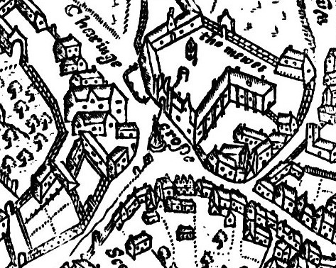
English: John Norden's Map of Westminster, 1593, engraved by Pieter Van den Keere. Original size 9.5 x 6.75 inches, published in Norden's "Middlesex", dated 1593. Norden was born c. 1548, and was made Surveyor of His Majesty's Woods in 1609. Detail of Charing Cross and surrounding area. The map is oriented with north-west to the top: Whitehall is to the bottom left, and the Strand to the bottom right. |
| Datum | |
| Bron | File:John Norden's Map of Westminster Large version.jpeg |
| Auteur | John Norden, 1593 |
Licentie
|
Dit werk bevindt zich in het publiek domein in landen en gebieden waar de auteursrechttermijn het leven van de auteur plus 70 jaar of minder is. Dit werk bevindt zich in het publiek domein in de Verenigde Staten omdat het gepubliceerd werd (of geregistreerd bij de U.S. Copyright Office) voor 1 januari 1929. | |
| Van dit bestand is vastgesteld dat er geen bekende auteursrechtaanspraken op rusten, alle aanverwante en naburige rechten daarbij inbegrepen. | |
Bestandsgeschiedenis
Klik op een datum/tijd om het bestand te zien zoals het destijds was.
| Datum/tijd | Miniatuur | Afmetingen | Gebruiker | Opmerking | |
|---|---|---|---|---|---|
| huidige versie | 14 jun 2019 22:16 | | 473 × 378 (154 kB) | GrindtXX | User created page with UploadWizard |
Bestandsgebruik
Dit bestand wordt op de volgende pagina gebruikt:
Globaal bestandsgebruik
De volgende andere wiki's gebruiken dit bestand:
- Gebruikt op de.wikipedia.org
- Gebruikt op en.wikipedia.org
- Gebruikt op es.wikipedia.org