Bestand:Nile River and delta from orbit.jpg

Pagina-inhoud wordt niet ondersteund in andere talen.
Uit Wikipedia, de vrije encyclopedie

Nile_River_and_delta_from_orbit.jpg(700 × 550 pixels, bestandsgrootte: 85 kB, MIME-type: image/jpeg)


Beschrijving

Beschrijving

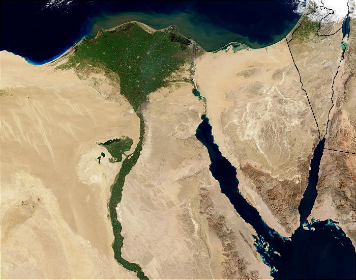
Nile River and delta from orbit Description: The Nile River and delta as seen from space by the MODIS sensor on the Terra satellite.

"Against the barren desert of northeastern Africa, the fertile valley of the Nile River runs northward through Egypt. In the higher-resolution images, the city of Cairo can be seen as a gray smudge right where the river widens into its broad fan-shaped delta. Other cities are dotted across the green landscape, giving it a speckled appearance. Where the Nile empties into the Mediterranean Sea (top) the waters are swirling with color, likely a mixture of sediment, organic matter, and possibly marine plant life. Farther west, the bright blue color of the water is likely less-organically rich sediment, perhaps sand.
"East of the delta lies the arid Sinai Peninsula, whose pointed tip is home to rugged mountains, some as high as 8,600 feet. The lattice work of pale lines marks the paths of ephemeral rivers. The Sinai Peninsula intrudes into the Red Sea. Farther east are Israel, Jordan, and Saudi Arabia. At top right is the disputed territory of the West Bank.
"In the false-color image, vegetation is bright green, water is dark blue or black, and clouds are light blue. It's interesting to notice that places that seem essentially arid, or desert-like in the true-color image in fact have a delicate layer of vegetation. For example, the central Sinai Peninsula, and most of Israel have a faint greenish tinge in the false-color images.
Datum
Bron http://visibleearth.nasa.gov/view_rec.php?id=4927 [1]
Auteur Jacques Descloitres, MODIS Rapid Response Team, NASA/sh
Andere versies Cuaggjacgacugvajgca

Salchicha

Licentie

Public domain Dit bestand bevindt zich in het publiek domein, omdat het gemaakt is door de NASA. In de reproductierichtlijnen van de NASA staat dat "NASA-materiaal niet beschermd wordt door auteursrecht, tenzij anders vermeld".

(NASA copyright policy page of JPL Image Use Policy).

Waarschuwingen:
  • Het gebruik van logo's, insignes en emblemen van de NASA wordt beperkt door de Amerikaanse wet 14 CFR 1221.
  • Op de website van de NASA staat een groot aantal afbeeldingen van het Sovjet-/Russisch ruimteagentschap en andere niet-Amerikaanse ruimteagentschappen. Deze afbeeldingen bevinden zich niet noodzakelijk in het publieke domein.
  • Materiaal dat gebaseerd is op gegevens van de ruimtetelescoop Hubble wordt mogelijk beschermd door auteursrecht als dit niet expliciet vervaardigd is door het STScI [2]. Zie tevens {{PD-Hubble}} en {{Cc-Hubble}} of {{Spacetelescope.org}}.
  • Het gemeenschappelijk project van ESA en NASA betreffende de ruimtesonde SOHO suggereert dat al het materiaal dat gemaakt is door zijn ruimtesonde beschermd wordt door auteursrecht en dat toestemming vereist is voor commercieel niet-educatief gebruik. [3]
  • Afbeeldingen op de Astronomy Picture of the Day-website (APOD) worden mogelijk beschermd door auteursrecht. [4]

Bijschriften

Beschrijf in één regel wat dit bestand voorstelt
Nile delta

Items getoond in dit bestand

beeldt af

image/jpeg

Bestandsgeschiedenis

Klik op een datum/tijd om het bestand te zien zoals het destijds was.

Datum/tijdMiniatuurAfmetingenGebruikerOpmerking
huidige versie30 nov 2004 00:47Miniatuurafbeelding voor de versie van 30 nov 2004 00:47700 × 550 (85 kB)MschlindweinNile River and delta from orbit

Dit bestand wordt op de volgende 2 pagina's gebruikt:

Globaal bestandsgebruik

De volgende andere wiki's gebruiken dit bestand:

Globaal gebruik van dit bestand bekijken.