
Bestand:Spratly Islands.png

Geen hogere resolutie beschikbaar.
Spratly_Islands.png (330 × 354 pixels, bestandsgrootte: 8 kB, MIME-type: image/png)
| Dit is een bestand van Wikimedia Commons. Onderstaande beschrijving komt van de beschrijving van het bestand daar. |
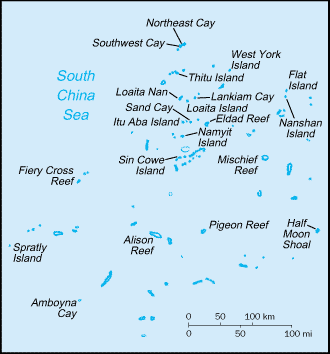
Beschrijving
Map of the Spratly Islands from http://www.lib.utexas.edu/maps/cia03/spratly_islands_sm03.gif CIA World Factbook].
Licentie
Deze afbeelding bevindt zich in het publiek domein omdat het materiaal bevat dat oorspronkelijk afkomstig is van het CIA World Factbook.
|
 |
Bestandsgeschiedenis
Klik op een datum/tijd om het bestand te zien zoals het destijds was.
| Datum/tijd | Miniatuur | Afmetingen | Gebruiker | Opmerking | |
|---|---|---|---|---|---|
| huidige versie | 4 feb 2006 10:43 | | 330 × 354 (8 kB) | Magalhães | Map of the Spratly Islands from http://www.lib.utexas.edu/maps/cia03/spratly_islands_sm03.gif CIA World Factbook]. {{PD-USGov-CIA-WF}} |
Bestandsgebruik
Dit bestand wordt op de volgende pagina gebruikt:
Globaal bestandsgebruik
De volgende andere wiki's gebruiken dit bestand:
- Gebruikt op eo.wikipedia.org