
Bestand:Val di Susa mappa.png

Grootte van deze voorvertoning: 800 × 532 pixels. Andere resoluties: 320 × 213 pixels | 640 × 425 pixels | 1.024 × 681 pixels | 1.280 × 851 pixels | 1.625 × 1.080 pixels.
Oorspronkelijk bestand (1.625 × 1.080 pixels, bestandsgrootte: 769 kB, MIME-type: image/png)
| Dit is een bestand van Wikimedia Commons. Onderstaande beschrijving komt van de beschrijving van het bestand daar. |
Beschrijving

|
Deze kaartafbeelding zou opnieuw moeten worden aangemaakt als een SVG-bestand door vectorafbeeldingen te gebruiken. Dit heeft een aantal voordelen; zie Commons:Media for cleanup voor meer informatie. Als er een SVG-formaat van deze afbeelding bestaat, dan deze graag uploaden. Nadat u dit heeft gedaan, gelieve dit sjabloon te vervangen door het sjabloon {{vector version available|nieuwe bestandsnaam.svg}} op deze afbeeldingspagina.
|
| Beschrijving |
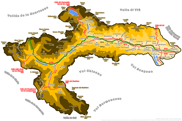
English: Map of Susa Valley, Piemonte, Italy
Italiano: Mappa della Valle di Susa
Deutsch: Karte des Susatals in Italien |
| Datum | |
| Bron | map drawn by Duvilar (Lorenzo Rossetti) |
| Auteur | Duvilar (Lorenzo Rossetti) |
| Toestemming (Hergebruik van dit bestand) |
Ik, de auteursrechthebbende van dit werk, maak het hierbij onder de volgende licentie beschikbaar: Dit bestand is gelicenseerd onder de Creative Commons-licentie Naamsvermelding-Gelijk delen 3.0 Unported
va necessariamente accompagnata dal nome del sottoscritto autore Lorenzo Rossetti. Un utilizzo senza indicazione della paternità dell'opera sarà considerato come violazione del diritto d'autore. Contatto per maggiori informazioni. The publication of this image outside Wikipedia must be accompanied by the name of the undersigned author Lorenzo Rossetti. Its use without indication of the author's name will be considered as copyright violation. Contact for more information. |
Bestandsgeschiedenis
Klik op een datum/tijd om het bestand te zien zoals het destijds was.
| Datum/tijd | Miniatuur | Afmetingen | Gebruiker | Opmerking | |
|---|---|---|---|---|---|
| huidige versie | 9 jan 2011 19:26 | | 1.625 × 1.080 (769 kB) | Duvilar | new version |
| 3 aug 2010 12:22 |  | 1.625 × 1.080 (823 kB) | Duvilar | Nuova versione più completa More complete new version | |
| 29 aug 2009 14:46 |  | 2.400 × 1.488 (903 kB) | Duvilar | Aggiunti i Comuni mancanti e le parti della Valle di Susa sotto amministrazione francese o congiunta italo-francese (Moncenisio e Valle Stretta, confini sullo spartiacque del 1861 e successive rettifiche del 1947). | |
| 2 sep 2006 19:04 |  | 2.390 × 1.442 (559 kB) | Duvilar | == Dettagli == {{Information| |Description ={{english}} Map of Susa Valley, Piemonte, Italy {{italian}} Mappa della Valle di Susa |Source = map drawn by Duvilar |Date = 02 Sep. 2006 |Author = Duvilar |Permiss |
Bestandsgebruik
Dit bestand wordt op de volgende pagina gebruikt:
Globaal bestandsgebruik
De volgende andere wiki's gebruiken dit bestand:
- Gebruikt op ar.wikipedia.org
- Gebruikt op bg.wikipedia.org
- Gebruikt op br.wikipedia.org
- Gebruikt op ca.wikipedia.org
- Gebruikt op de.wikipedia.org
- Gebruikt op en.wikipedia.org
- Gebruikt op es.wikipedia.org
- Gebruikt op fr.wikipedia.org
- Gebruikt op it.wikipedia.org
- Gebruikt op it.wikinews.org
- Gebruikt op it.wikivoyage.org
- Gebruikt op ja.wikipedia.org
- Gebruikt op la.wikipedia.org
- Gebruikt op pms.wikipedia.org
- Gebruikt op pt.wikipedia.org
- Gebruikt op ru.wikipedia.org
- Gebruikt op sl.wikipedia.org
- Gebruikt op zh.wikipedia.org