
Bestand:Water stress 2019 WRI.png
Grootte van deze voorvertoning: 800 × 351 pixels. Andere resoluties: 320 × 140 pixels | 640 × 281 pixels | 1.425 × 625 pixels.
Oorspronkelijk bestand (1.425 × 625 pixels, bestandsgrootte: 54 kB, MIME-type: image/png)
| Dit is een bestand van Wikimedia Commons. Onderstaande beschrijving komt van de beschrijving van het bestand daar. |
Beschrijving
| Beschrijving |
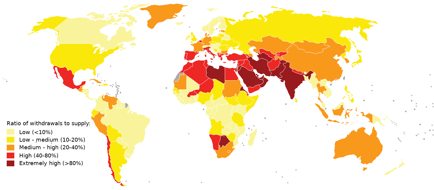
English: 2019 water stress map.
Compiled using aqueduct 3.0 data from World Resources Institute See table "National Water Stress Rankings" at https://www.wri.org/blog/2019/08/17-countries-home-one-quarter-world-population-face-extremely-high-water-stress and https://www.wri.org/applications/aqueduct/country-rankings/ Legend was made similar as in an earlier WRI map (aqueduct 2.0), see https://www.wri.org/resources/data-sets/aqueduct-projected-water-stress-country-rankings What's colored in grey means no data available (i.e. western sahara, french guyana) |
| Datum | |
| Bron | Eigen werk |
| Auteur | Genetics4good |
Licentie
Ik, de auteursrechthebbende van dit werk, maak het hierbij onder de volgende licentie beschikbaar:

|
Toestemming wordt verleend voor het kopiëren, verspreiden en/of wijzigen van dit document onder de voorwaarden van de GNU-licentie voor vrije documentatie, versie 1.2 of enige latere versie als gepubliceerd door de Free Software Foundation; zonder Invariant Sections, zonder Front-Cover Texts, en zonder Back-Cover Texts. Een kopie van de licentie is opgenomen in de sectie GNU-licentie voor vrije documentatie. |
Bestandsgeschiedenis
Klik op een datum/tijd om het bestand te zien zoals het destijds was.
| Datum/tijd | Miniatuur | Afmetingen | Gebruiker | Opmerking | |
|---|---|---|---|---|---|
| huidige versie | 11 aug 2019 15:38 | | 1.425 × 625 (54 kB) | Genetics4good | {{Information |description ={{en|1=2019 water stress map. Compiled using aqueduct 3.0 data from World Resources Institute See table "National Water Stress Rankings" at https://www.wri.org/blog/2019/08/17-countries-home-one-quarter-world-population-face-extremely-high-water-stress and https://www.wri.org/applications/aqueduct/country-rankings/ Legend was made similar as in an earlier WRI map (aqueduct 2.0), see https://www.wri.org/resources/data-sets/aqueduct-projected-water-stress-country-r... |
Bestandsgebruik
Dit bestand wordt op de volgende pagina gebruikt:
Globaal bestandsgebruik
De volgende andere wiki's gebruiken dit bestand:
- Gebruikt op el.wikipedia.org
- Gebruikt op en.wikipedia.org
- Gebruikt op fr.wikipedia.org
- Gebruikt op hi.wikipedia.org
- Gebruikt op it.wikipedia.org
- Gebruikt op ja.wikipedia.org
- Gebruikt op ms.wikipedia.org
- Gebruikt op pt.wikipedia.org
- Gebruikt op sv.wikipedia.org
- Gebruikt op te.wikipedia.org
- Gebruikt op uk.wikipedia.org
- Gebruikt op www.wikidata.org
- Gebruikt op zh.wikipedia.org